
Đôi dòng Lịch Sử
-Ngày 1-6-1956, VNCH đưa ra thông báo xác nhận chủ quyền trên quần đảo Trường Sa.
-Ngày 15-6-1956, Bắc Việt (Đồng Văn Khiêm) xác nhận Hoàng Sa -Trường Sa là của Trung Cộng.
-Ngày 4-9-1958,Trung Cộng tuyên bố HS/TS là của Trung Cộng.
-Ngày 14-9-1958, Bắc Việt (Phạm Văn Đồng) gửi Công hàm tuyên bố tôn trọng hải phận 12 hải lý bao gồm Hoàng Sa- Trường Sa của Trung Cộng.
Trước 1975, quần đảo Trường Sa do VNCH trấn giữ, chỉ trừ đảo lớn nhất là đảo Ba Bình (Itu Aba) do Đài Loan chiếm đóng từ năm 1946. Ngay sau khi đưa quân ra trấn đóng quần đảo Trường Sa, ông Diệm có đòi Đài Loan phải trả lại đảo Ba Bình, nhưng rồi vì chiến tranh trong đất liền mỗi ngày một khốc liệt, nên VNCH đã tạm gác qua một bên...
Năm 1974, Trung Cộng đánh chiếm Hoàng Sa từ tay Việt Nam Cộng Hòa.
Năm 1988, Trung Quốc đánh chiếm một số đảo từ tay Việt Nam.
BIỂN ĐÔNG / South China Sea
Đông Nam Á được mệnh danh là vịnh Ba Tư thứ hai với tiềm năng lớn về dầu, khí đốt và là tuyến vận chuyển huyết mạch của thế giới. Theo Trung Tâm Nghiên cứu Chiến lược Toàn cầu, một lượng hàng hóa trị giá khoảng 5.300 tỉ USD được vận chuyển qua biển Đông mỗi năm.

Biển Đông (tên quốc tế thông dụng: Nam Hải) là một biển rìa lục địa (marginal sea), một phần của Thái Bình Dương, bao phủ một diện tích từ Singapore tới eo biển Đài Loan với diện tích áng chừng khoảng 3,500,000 km². Đây là một hình thể biển lớn nhất sau năm đại dương. Các đảo ở Biển Đông có số lượng nhiều, tập hợp thành một số quần đảo. Vùng biển này và phần lớn các đảo không có người ở của nó là mục tiêu tranh chấp chủ quyền của nhiều quốc gia xung quanh. Những tranh chấp đó cũng thể hiện ở số lượng tên gọi được sử dụng để chỉ vùng biển này.
CÁC TÊN CỦA VÙNG BIỂN
South China Sea là thuật ngữ phổ biến nhất trong tiếng Anh để chỉ vùng biển này, và tên trong đa số các ngôn ngữ Châu Âu khác cũng như vậy, nhưng các nước xung quanh thì gọi nó bằng nhiều tên khác nhau, thường phản ánh chủ quyền lịch sử của họ đối với quyền bá chủ vùng biển.
Trung Quốc gọi tắt biển này là Nam Hải 南海. Trong ngành xuất bản hiện nay của Trung Quốc, nó thường được gọi là Nam Trung Quốc Hải 南中國海, và cái tên này cũng thường được dùng trong các bản đồ bằng tiếng Anh do Trung Quốc ấn hành. Philippines gọi là biển Luzón theo tên hòn đảo lớn Luzon của Philippine.Tại Việt Nam, hầu hết lãnh thổ hướng chính ra biển là hướng đông, do đó tên tiếng Việt của biển này hàm nghĩa là vùng biển Đông Việt Nam. Ở đồng bằng sông Cửu Long có thể ra biển về hướng tây (vịnh Thái Lan) về phía các nước Campuchia và Thái Lan. Biển Đông Việt Nam còn ghi dấu ấn của mình vào văn hóa và lịch sử Việt Nam, thể hiện qua câu tục ngữ "thuận vợ thuận chồng tát biển Đông cũng cạn; Thuận bè, thuận bạn tát cạn biển Đông", hay thành ngữ "dã tràng xe cát biển Đông". Người Trung Quốc ở đảo Hải Nam thì có câu "phúc như Đông hải, thọ tỉ Nam sơn"[1]. Trong các tài liệu cổ về hàng hải của Bồ Đào Nha vào thế kỉ 15-16 còn có tên là Biển Chăm Pa.
Ngoài ra còn có East China Sea (tên quốc tế của biển này) ở phía bắc so với biển Đông Việt Nam, Trung Quốc gọi tắt là Đông Hải, khi tra cứu những tài liệu của Trung Quốc hoặc của nước khác tham khảo tài liệu Trung Quốc, chú ý không nhầm lẫn hai biển Đông này.
Tên gọi quốc tế của biển Đông ra đời từ nhiều thế kỷ trước, là biển Nam Trung Hoa vì thời bấy giờ Trung Quốc là nước rộng lớn nhất, phát triển nhất, nổi tiếng nhất trong khu vực và đã có giao thương với phương Tây qua con đường tơ lụa. Tên gọi nhiều biển, đại dương vốn căn cứ vào vị trí của chúng so với các vùng đất gần đó cho dễ tra cứu, không có ý nói về chủ quyền. Có thể kể ra các thí dụ là Ấn Độ Dương, là đại dương ở phía nam Ấn Độ, giáp nhiều nước ở châu Á và châu Phi, không phải là của riêng nước Ấn Độ; hay biển Nhật Bản, được bao quanh bởi Nga, Bắc Triều Tiên, Hàn Quốc và Nhật Bản.
ĐỊA DANH TRONG BIỂN ĐÔNG
Vịnh Bắc Bộ là phần biển Đông giữa miền Bắc Việt Nam với Đảo Hải Nam miền Nam Trung Quốc. Bờ phía Tây là bờ biển Việt Nam từ Thanh Hóa đến Móng Cái. Phía bắc từ Móng Cái trở sang phía Đông là 2 tỉnh Quảng Tây, Quảng Đông của Trung Quốc với bán đảo Lôi Châu. Bờ Đông là đảo Hải Nam của Trung Quốc. Trong vịnh có hàng nghìn đảo nhỏ, nổi tiếng nhất là các đảo trong vịnh Hạ Long được UNESCO xếp loại là di sản thiên nhiên thế giới. Đảo Bạch Long Vĩ thuộc Việt Nam ở giữa vịnh, có diện tích khoảng 2,5 km².Hai quần đảo Hoàng Sa và Trường Sa ở giữa biển Đông đã được nhiều chính quyền Việt Nam liên tục thực hiện chủ quyền từ nhiều thế kỷ qua. Quần đảo Hoàng Sa do Trung Quốc dùng bạo lực chiếm giữ một phần từ những năm 1950 và hoàn toàn từ năm 1974. Tranh chấp chủ quyền, một phần hay toàn bộ, cũng đã diễn ra tại quần đảo Trường Sa giữa Việt Nam, Trung Quốc, Philippines, Malaysia, Indonesia, Brunei và Đài Loan.
Những lý do chính để các nước tranh chấp chủ quyền hai quần đảo trên là:
- Diện tích lãnh hải với đặc quyền kinh tế và việc triển khai quốc phòng.
- Biển Đông nằm trên một trong những đường giao thông hàng hải lớn trên thế giới, có nguồn thủy sản và tiềm năng dầu khí.
Tổ chức thuỷ văn học quốc tế xác định vùng biển trải dài theo hướng từ tây nam đến đông bắc, biên giới phía nam là 3 độ vĩ độ Nam giữa Nam Sumatra và Kalimantan (eo biển Karimata), và biên giới phía bắc của nó là eo biển Đài Loan từ mũi phía bắc Đài Loan tới bờ biển Phúc Kiến thuộc đại lục Trung Quốc. Vịnh Thái Lan chiếm phần phía tây của biển Đông.
Biển nằm trên một thềm lục địa ngầm; trong những kỷ băng hà gần đây nước biển đã hạ thấp xuống hàng trăm mét, và Borneo từng là một phần của lục địa Châu Á.
Các nước và lãnh thổ có biên giới với vùng biển này (theo chiều kim đồng hồ từ phía bắc) gồm: đại lục Trung Quốc, Macao, Hồng Kông, Đài Loan, Philippines, Malaysia, Brunei, Indonesia, Singapore, Thái Lan, Campuchia, và Việt Nam.
Nhiều con sông lớn chảy vào Biển Đông gồm các sông Châu Giang, Mân Giang, sông Cửu Long (Phúc Kiến), sông Hồng, sông Mê Kông, sông Rajang, sông Pahang, và sông Pasig.

CÁC ĐẢO VÀ ĐÁ NGẦM
Phía đông bắc Biển Đông có quần đảo Đông Sa, thuộc Trung Quốc (Pratas Islands), mà Đài Loan cũng tuyên bố chủ quyền.
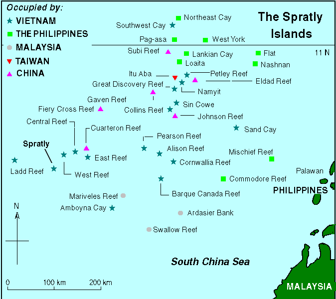
Bên trong vùng biển, có hơn 200 đảo và bãi đá ngầm đã được đặt tên, đa số chúng thuộc Quần đảo Trường Sa. Quần đảo Trường Sa trải dài trên một vùng rộng 810, dài 900 km với khoảng 175 đảo đã được xác định, hòn đảo lớn nhất là đảo Ba Bình (Itu Aba) với chỉ hơn 1,3 km chiều dài và điểm cao nhất là 3,8 mét.
Có một núi ngầm rộng 100 km được gọi là Reed Tablemount ở đông bắc quần đảo Trường Sa, cách biệt khỏi đảo Palawan của Philippine bởi Rãnh Palawan. Hiện nay nằm sâu 20m dưới mực nước biển nhưng trước kia nó từng là một hòn đảo trước khi bị mực nước biển dâng lên ở thời băng hà cuối cùng làm chìm ngập.Phía đông quần đảo Hoàng Sa có các bãi ngầm như Macclesfield Bank (quần đảo Trung Sa), Stewart Bank, Truro Shoal và Scarborough Shoal.
- Bãi Scarborough Shoal
- Vị trí: nằm về phía Đông của bãi Macclesfield, gần bờ biển Philippines
- Hình thể: là một bãi khá lớn bên dưới là đá ngầm. Bãi này nằm dưới mặt biển chừng 92 fathoms.
- Bãi Truro Shoal: nằm bên cạnh Scarborough Shoal, sâu 10 fathoms
- Bãi Stewart Bank: (578 fathoms) gần đảo Luzon của Philippines.
CÁC NGUỒN TÀI NGUYÊN
Đây là một vùng biển có ý nghĩa địa chính trị vô cùng quan trọng. Nó là đường hàng hải đông đúc thứ hai trên thế giới, trong khi nếu tính theo tổng lượng hàng hoá thương mại chuyển qua hàng năm, hơn 50% đi qua Eo biển Malacca, Eo Sunda, và Eo Lombok. Hơn 1.6 million m³ (10 triệu barrels) dầu thô được chuyển qua eo biển Malacca hàng ngày, nơi thường xảy ra các vụ hải tặc, nhưng hiện đã giảm nhiều so với giữa thế kỷ 20.Vùng này đã được xác định có trữ lượng dầu mỏ khoảng 1.2 km³ (7.7 tỷ barrel), với ước tính tổng khối lượng là 4.5 km³ (28 tỷ barrels). Trữ lượng Khí gas tự nhiên được ước tính khoảng 7,500 km³ (266 nghìn tỷ feet khối).
Theo những nghiên cứu do Sở môi trường và các nguồn lợi tự nhiên Philippine, vùng biển này chiếm một phần ba toàn bộ đa dạng sinh học biển thế giới, vì vậy nó là vùng rất quan trọng đối với hệ sinh thái.
TUYÊN BỐ LÃNH HẢI

Biển Đông, các khu vực và tài nguyên tranh chấp giữa các nước.
- Indonesia và CHNDTH về vùng biển Đông Bắc đảo Natuna.
- Philippines và CHNDTH về những khu khai thác khí gas Malampaya và Camago.
- Philippines và CHNDTH về bãi cát ngầm Scarborough.
- Việt Nam và CHNDTH về vùng biển phía tây Quần đảo Trường Sa. Một số hay toàn bộ quần đảo Trường Sa đang bị tranh chấp bởi Việt Nam, CHNDTH, Trung Hoa Dân quốc, Philippines, và một số nước khác.
- Quần đảo Hoàng Sa đang dưới sự quản lý và tuyên bố chủ quyền của Việt Nam, CHNDTH quản lý 6 đảo từ năm 1974 đến nay.
- Malaysia, Campuchia, Thái Lan và Việt Nam về những vùng ở Vịnh Thái Lan.
- Singapore và Malaysia dọc theo Eo biển Johore và Eo biển Singapore.
ASEAN nói chung, và Malaysia nói riêng luôn muốn đảm bảo rằng những tranh chấp bên trong Biển Đông sẽ không leo thang trở thành xung đột quân sự. Vì vậy, các cơ cấu phát triển chung (Joint Development Authorities) đã được lập ra tại các vùng tranh chấp chồng lấn để cùng phát triển vùng và phân chia quyền lợi công bằng tuy nhiên không giải quyết vấn đề chủ quyền của vùng đó. Điều này đã trở thành sự thực, đặc biệt là ở Vịnh Thái Lan.
Những tuyên bố lãnh thổ chồng lần ở Pulau Pedra Branca hay Pulau Batu Putih của cả Singapore và Malaysia đã được đưa ra Toà án quốc tế. Toà án phán quyết theo chiều hướng có lợi cho Singapore.
 |
Bản đồ Việt Nam với hai quần đảo Hoàng Sa và Trường Sa
do người Hà Lan vẽ năm 1754
|
SPRATLY ISLANDS
Chinese name
Traditional Chinese: 南沙群島
Transliterations
- Hanyu Pinyin: Nánshā Qúndǎo
- Jyutping: nam4 saa1 kwun4 dou2
Filipino name
Tagalog: Kapuluan ng
Kalayaan
Malay name
Malay: Kepulauan Spratly
Vietnamese name
Quốc ngữ: Quần Đảo Trường Sa
Hán tự: 長沙群島
About 45 islands are occupied by relatively small numbers of military forces from China, Malaysia, the Philippines, Taiwan, and Vietnam. Brunei has established a fishing zone that overlaps a southern reef but has not made any formal claim.
Geography and economic development
- Coordinates:
8°38′N 111°55′E / 8.633, 111.917Coordinates:
- Area (land): less than 5 km²
- note: includes 148 or so islets, coral reefs, and seamounts scattered over an area of nearly 410,000 km² of the central South China Sea
- Coastline: 926 km
- Political divisions:
- Vietnam: Part of Khanh Hoa Province;
- People's Republic of China: Part of the Paracels, Spratlys, and Zhongsha Islands Authority, Hainan province;
- Philippines: Part of Palawan province;
- Malaysia: Part of the state of Sabah (also claimed by the Philippines);
- Republic of China: Part of Kaohsiung municipality
- Climate: tropical
- Terrain: flat
- Elevation extremes:
- lowest point: South China Sea (0 m)
- highest point: unnamed location on Southwest Cay (4 m)
- Natural hazards: typhoons; serious maritime hazards because of numerous banks, reefs and shoals
Early history

Geographic map of Spratlys. The first possible recorded human interaction with the Spratly Islands dates back as far as 3 B.C. This is based on the discovery that the people of Nanyue (Nam Việt, southern China and northern Vietnam) and Old Champa kingdom fishermen (modern-day central Vietnam) had been visiting the Spratly Islands and other South China Sea Islands for fishing.
Ancient Chinese maps record the Qianli Changsha 千里長沙 and Wanli Shitang 萬里石塘, which China today claims refer to these islands. These islands were labeled as Chinese territory since the Yuan Dynasty in the 13th century,[1] followed by the Ming Dynasty.[2] When the Ming Dynasty collapsed, the Qing Dynasty continued to include the territory in maps complied in 1724,[3] 1755,[4] 1767,[5] 1810,[6] 1817[7] by the Qing Dynasty of China.
Ancient Vietnamese maps record Bãi Cát Vàng (Golden Sandbanks, as claimed today by Vietnam referring to both Paracel and Spratly Islands) which lies near the Coast of the central Vietnam as early as the 17th century. In Phủ Biên Tạp Lục (Frontier Chronicles) by the scholar Le Quy Don, Hoàng Sa and Trường Sa were defined as belonging to Quảng Ngãi District. He described it as where sea products and shipwrecked cargoes were available to be collected. Vietnamese text written in the 17th century referenced government-sponsored economic activities during the Le Dynasty, 200 years earlier. The Vietnamese government conducted several geographical surveys of the islands in the 18th century.
The islands were sporadically visited throughout the nineteenth and early twentieth centuries by mariners from different European powers (including either Richard Spratly or William Spratly, after whom the island group derives its most recognizable English name). However, these nations showed little interest in the islands. In 1883, German boats surveyed the Spratly and Paracel Islands but withdrew the survey eventually after receiving protests from the Nguyen Dynasty.
In the 1933, France claimed the Spratly and Paracel Islands on behalf of its then-colony Vietnam. It occupied a number of the Spratly Islands, including Itu Aba, built weather stations on two, and administered them as part of French Indochina. This occupation was protested by the Republic of China government because France admitted finding Chinese fishermen there when French war ships visited nine islands. In 1935, the Chinese government also announced a sovereignty claim on the Spratly Islands. Japan occupied some of the islands in 1939 during World War II, and used the islands as a submarine base for the occupation of Southeast Asia. During the occupation, these islands were called Shinnan Shoto 新南諸島, literally the New Southern Islands, and put under the governance of Taiwan together with the Paracel Islands 西沙群岛. Today, Itu Aba Island is still administrated by the Republic of China (Taiwan).
Following the defeat of Japan at the end of World War II, the Republic of China government (Nationalist) re-claimed the entirety of the Spratly Islands (including Itu Aba), accepting the Japanese surrender on the islands based on the Cairo and Potsdam Declarations. Several years later, the Nationalist Chinese government withdrew from most of the Spratly and Paracel Islands after they were defeated by the forces of the opposing Communist Party of China in 1949.
Japan renounced all claims to the islands in 1951 San Francisco Peace Treaty, together with the Paracels, Pratas & other islands captured from China, upon which China reasserted its claim to the islands.
The naval units of the Vietnamese government took over in Trường Sa after the defeat of the French at the end of the First Indochina War. In 1958, the People's Republic of China issued a declaration defining its territorial waters, which encompassed the Spratly Islands. North Vietnam's prime minister, Pham Van Dong, sent a formal note to Zhou Enlai, stating that "The Government of the Democratic Republic of Vietnam respects this decision."[8]
Political dispute
In 1968 oil was discovered in the region. The Geology and Mineral Resources Ministry of the People's Republic of China (PRC) has estimated that the Spratly area holds oil and natural gas reserves of 17.7 billion tons (1.60 × 10¹⁰ kg), as compared to the 13 billion tons (1.17 × 10¹⁰ kg) held by Kuwait, placing it as the fourth largest reserve bed in the world. Naturally, these large reserves assisted in intensifying the situation and propelled the territorial claims of the neighboring countries.
On 11 March 1976, the first major Philippine oil discovery occurred off the coast of Palawan, within the Spratly Islands territory, and these oil fields now account for fifteen percent of all petroleum consumed in the Philippines.
In 1992, the PRC and Vietnam granted oil exploration contracts to U.S. oil companies that covered overlapping areas in the Spratlys.
In May 1992, the China National Offshore Oil Corporation (CNOOC) and Crestone Energy (a U.S. company based in Denver, Colorado) signed a cooperation contract for the joint exploration of the Wan'an Bei-21 block, a 25,155 km² section of the southwestern South China Sea that includes Spratly Island areas. Part of the Crestone's contract covered Vietnam’s blocks 133 and 134, where PetroVietnam and ConocoPhillips Vietnam Exploration & Production, a unit of ConocoPhillips, agreed to evaluate prospects in April 1992. This led to a confrontation between China and Vietnam, with each demanding that the other cancel its contract.
An additional motive is the region's role as one of the world's most productive areas for commercial fishing. In 1988, for example, the South China Sea accounted for eight percent of the total world catch, a figure which has certainly risen. The PRC has predicted that the South China Sea holds combined fishing and oil and gas resources worth one trillion dollars. There have already been numerous clashes between the Philippines and other nations — particularly the PRC — over foreign fishing vessels in its Exclusive Economic Zone (EEZ) and the media regularly report the arrest of Chinese fishermen. In 1984, Brunei established an exclusive fishing zone encompassing Louisa Reef in the southern Spratly Islands, but has not publicly claimed the island. The region is also one of the busiest shipping lanes in the world. During the 1980s, at least two hundred and seventy ships passed through the Spratly Islands region each day, and currently more than half of the world's supertanker traffic, by tonnage, passes through the region’s waters every year. Tanker traffic through the South China Sea is over three times greater than through the Suez Canal and five times more than through the Panama Canal; twenty five percent of the world’s crude oil passes through the South China Sea.
There have been occasional naval clashes over the Spratly Islands. In 1988, China and Vietnam clashed at sea over possession of Johnson Reef in the Spratlys. Chinese gunboats sank Vietnamese transport ships supporting a landing party of Vietnamese soldiers.
In response to growing concerns by coastal states regarding encroachments by foreign vessels on their natural resources, the United Nations convened the United Nations Convention on the Law of the Sea (UNCLOS) in 1982 to determine the issue of international sea boundaries. In response to these concerns, it was resolved that a coastal state could claim two hundred nautical miles of jurisdiction beyond its land boundaries. However UNCLOS failed to address the issue of how to adjudicate on overlapping claims and so the future of the islands remains clouded.
Following a 1995 dispute between China and the Philippines an ASEAN-brokered agreement was reached between the PRC and ASEAN member nations whereby a nation would inform the others of any military movement within the disputed territory and that there would be no further construction. The agreement was promptly violated by China and Malaysia. Claiming storm damage, seven Chinese naval vessels entered the area to repair "fishing shelters" in Panganiban Reef. Malaysia erected a structure on Investigator Shoal and landed at Rizal Reef. In response the Philippines lodged formal protests, demanded the removal of the structures, increased naval patrols in Kalayaan and issued invitations to American politicians to inspect the PRC bases by plane.
In the early 21st century, the situation is improving. China recently held talks with ASEAN countries aimed at realizing a proposal for a free trade area between the ten countries involved. China and ASEAN also have been engaged in talks to create a code of conduct aimed at easing tensions in the disputed islands. On 5 March 2002, an agreement was reached, setting forth the desire of the claimant nations to resolve the problem of sovereignty "without further use of force". In November 2002, a Declaration on the Conduct of Parties in the South China Sea was signed, easing tensions but falling short of a legally-binding code of conduct.
Various Claims

Spratly islands map showing occupied features marked with the flags of countries occupying them.
People's Republic of China and Republic of China
In the Chinese view, the islands have been an integral part of China for nearly two thousand years and neighboring countries and European Powers took advantage of China's poor condition and diversity to impinge on its sovereignty.China claims to have found the islands in the Han Dynasty in 2 BC. The islands were claimed to have been marked on maps compiled during the time of Eastern Han Dynasty and Eastern Wu (one of the Three Kingdoms). Since the Yuan Dynasty, these islands have been labeled as Chinese territory in the 12th century,[1] followed by the Ming Dynasty[2] and the Qing Dynasty from the 13th to 19th Centuries.[3][7] In archaeological surveys the remains of Chinese pottery and coins have been found in the islands and are cited as proof for the Chinese claim.[9].
From 1932 to 1935, the Republic of China continued to include the territory in their administrative area through the Map Compilation Committee. When France claimed 9 islands of the territory in 1933, it immediately encountered a revolt from Chinese fishermen and a protest from the Republic of China government in Nanking. Although the Republic of China continued to claim the islands, the Second Sino-Japanese war drew its attention for the mean time from 1937 onwards. After the second world war, China reclaimed sovereignty over the islands through post World War II arrangements based on various treaties of the Allied Powers[9] and a hoarstone was built on the islands by China. In 1947, the government renamed 159 islands in the area.
In 1958, the People's Republic of China issued a declaration defining the Spratly Islands as its territorial waters. North Vietnam's prime minister, Pham Van Dong, sent a formal note to recognize these claims and stated that "The Government of the Democratic Republic of Vietnam (North Vietnam) respects this decision." However this note is claimed to be void because the Spratly islands belonged to the South Vietnam (Republic of Vietnam) at that time. A year before the end of the Vietnam War the army of the South Vietnamese still held the majority of the Spratly islands and when North Vietnam unified Vietnam, it continued to claim the Spratly islands as an integral part of Vietnam. Today, the troops of the People's Republic of China and the Republic of China (Taiwan) respectively are stationed in several islands, including the biggest, Taiping island.
Philippines
While the Philippines' claim to the Spratly Islands was first expressed in the United Nations General Assembly in 1946, Philippine involvement in the Spratlys did not begin in earnest until 1956, when on May 15, 1956, Filipino citizen and admiral Tomas Cloma proclaimed the founding of a new state, Kalayaan (Freedom Land).Cloma’s Kalayaan encompassed fifty three features spread throughout the eastern South China Sea, including Spratly Island proper, Itu Aba, Pag-asa and Nam Yit Islands, as well as West York Island, North Danger Reef, Mariveles Reef and Investigator Shoal. Cloma then established a protectorate in July 1956 with Pag-asa as its capital and Cloma as “Chairman of the Supreme Council of the Kalayaan State”.
This action, although not officially endorsed by the Philippine government, was considered by other claimant nations as an act of aggression by the Philippines and international reaction was swift.
Taiwan, the PRC, South Vietnam, France, the United Kingdom and the Netherlands lodged official protests (the Netherlands on the premise that it considered the Spratly Islands part of Dutch New Guinea) and Taiwan sent a naval task force to occupy the islands and establish a base on Itu Aba, which it retains to the present day.
Tomas Cloma and the Philippines continued to state their claims over the islands; in October 1956 Cloma traveled to New York to plead his case before the United Nations and the Philippines had troops posted on three islands by 1968 on the premise of protecting Kalayaan citizens. In early 1971 the Philippines sent a diplomatic note on behalf of Cloma to Taipei demanding the ROC's withdrawal from Itu Aba and on 10 July in the same year Ferdinand Marcos announced the annexation of the 53 island group known as Kalayaan, although since neither Cloma or Marcos specified which fifty three features constituted Kalayaan, the Philippines began to claim as many features as possible. In April 1972 Kalayaan was officially incorporated into Palawan province and was administered as a single “poblacion” (township), with Tomas Cloma as the town council Chairman and by 1992, there were twelve registered voters on Kalayaan. The Philippines also reportedly attempted to land troops on Itu Aba in 1977 to occupy the island but were repelled by ROC troops stationed on the island. There were no reports of casualties from the conflict. In 2005, a cellular phone base station was erected by the Philippines' Smart Communications on Pagasa Island.
The Philippines base their claims of sovereignty over the Spratlys on the issues of res nullius and geography. The Philippines contend Kalayaan was res nullius as there was no effective sovereignty over the islands until the 1930s when France and then Japan acquired the islands. When Japan renounced their sovereignty over the islands in the San Francisco Peace Treaty in 1951, there was a relinquishment of the right to the islands without any special beneficiary. Therefore, argue the Philippines, the islands became res nullius and available for annexation. Philippine businessman Tomas Cloma did exactly that in 1956 and while the Philippines never officially supported Cloma's claim, upon transference of the islands’ sovereignty from Cloma to the Philippines, the Philippines used the same sovereignty argument as Cloma did.
The Philippine claim to Kalayaan on geographical bases can be summarized using the assertion that Kalayaan is distinct from other island groups in the South China Sea because it is a generally accepted practice in oceanography to refer to a chain of islands through the name of the biggest island in the group or through the use of a collective name. Note that Spratly (island) has an area of only 13 hectares compared to the 22 hectare area of the Pagasa Island. Distance-wise, Spratly Island is some 210 nm off Pagasa Islands. This further stresses the argument that they are not part of the same island chain. The Paracels being much further (34.5 nm northwest of Pagasa Island) is definitely a different group of islands
A second argument used by the Philippines regarding their geographical claim over the Spratlys is that all the islands claimed by the Philippines lie within their archipelagic baselines, the only claimant who can make such a statement. The 1982 United Nations Convention on the Law of the Sea (UNCLOS) stated that a coastal state could claim two hundred nautical miles of jurisdiction beyond its land boundaries. It is perhaps telling that while the Philippines is a signatory to UNCLOS, the PRC and Vietnam are not. The Philippines also argue, under Law of the Sea provisions, that the PRC can not extend its baseline claims to the Spratlys because the PRC is not an archipelagic state. Whether this argument (or any other used by the Philippines) would hold up in court is debatable but possibly moot, as the PRC and Vietnam seem unwilling to legally substantiate their claims and have rejected Philippine challenges to take the dispute to the World Maritime Tribunal in Hamburg.
In addition to the aforementioned, Sabah, a state of Malaysia, is being claimed by the Philippines under legal and historical bases. So if the Philippines reclaimed Sabah, by default, Malaysia's claims to the Spratly Islands will be declared null, and it will be given to the Philippines, because Malaysia designated its claims to the Spratly Islands as a part of Sabah.
Vietnam
Vietnam also claims the islands on historical grounds. Vietnamese geographical maps record Bãi Cát Vàng (Golden Sandbanks, referring to Spratly Islands) as Vietnamese territory as early as the 17th century.In Phủ Biên Tạp Lục by the scholar Lê Quý Đôn, Hoàng Sa (Paracel Islands), and Trường Sa (Spratly Islands) were defined as belonging to Quảng Ngãi District. In Đại Nam Nhất Thống Toàn Đồ (Dai Nam Unified Map), an atlas of Vietnam completed in 1838, Trường Sa was shown as Vietnamese territory.
Vietnam had conducted many geographical and resource surveys of the islands. The results of these surveys have been recorded in Vietnamese literature and history published since the 17th century.
After the treaty signed with the Nguyen Dynasty, France represented Vietnam in international affairs and exercised sovereignty over the islands. On July 7, 1951, Tran Van Huu, head of the Bao Dai Government's delegation to the San Francisco Conference on the peace treaty with Japan declared that the archipelagoes of Hoang Sa and Truong Sa were part of Vietnamese territory. This declaration met with no challenge from the 51 representatives at the conference including delegates from both the People's Republic of China (mainland) and the Republic of China (Taiwan).
After the French left, the Vietnamese government exercised sovereignty over the islands. Vietnam currently occupies 31 islands. They are organized as a district of Khanh Hoa Province. At the 12th National Assembly Election held early in Trường Sa, the people and soldiers also voted for their local district government for the first time. For the first time, Trường Sa is organized like a normal inland district, with a townlet (thị trấn Trường Sa) and two communes (xã Sinh Tồn, xã Song Tử Tây). Forty nine people were elected to the communes' people's councils.
Others: Malaysia, Brunei also claim parts of the islands.
Tabular listing of features showing country possessions
Occupied Features
A feature is occupied by a country if one of the following is true:- Soldiers and/or civilian citizens of a country are present in the feature, either by building structures over the feature to house the citizens (most features are of this type) or by manning a ship anchored over the feature (Philippine-occupied Irving Reef is of this type).
- Regularly visited by soldiers of a country, not necessarily having soldiers present in it 24 hours. These features must lie near (within 9 miles (14 km)) a feature occupied by the country in the way of the first condition. Presence of structures is not necessary. This is the case of Philippine-occupied Flat Island and Lankiam Cay where soldiers stationed at Nanshan Island and Loaita Island respectively, regularly visit on a daily basis.
| Int'l Name | Local Names | Description | Area (ha.) |
| Flat Island[10][11] | The fourteenth largest Spratly island. About 6 miles (10 km) southwest of Philippine-occupied Lawak Island (Nanshan Island). It changes its shape seasonally. The sand build up will depend largely on the direction of prevailing wind and waves. It takes the shape of an elongated one for some years now and a shape like that of a crescent moon for few years ago and it formed the shape of a letter “S” in the past. Like Panata Island (Lankiam Cay), it is also barren of any vegetation. No underground water source is found in the island. Presently, this island serves only as a military observation post for the Municipality of Kalayaan. A low, flat, sandy cay, 240 by 90 m, subject to erosion. Has a nearby reef which is above water at high tide. With large guano deposits. No vegetation. Several soldiers stationed. | 0.57 | |
| Lankiam Cay[10][11] | The fifteenth largest and the smallest Spratly island. Located 8 miles (13 km) northeast of Philippine-occupied Kota Island (Lankiam Cay). A few years ago this island has a surface area of more than 5 hectares but strong waves brought by a strong typhoon washed out the sandy surface (beach) of the island leaving behind today the calcarenite foundation that can be seen at low tide. Several soldiers stationed. Part of Loaita Banks. | 0.44 | |
| Loaita Island[10][11] | The tenth largest Spratly island. Located 22 miles (35 km) southeast of Philippine-occupied Pag-asa Island (Thitu Island) and 22 miles (35 km) north-northeast of Taiwan-occupied Itu Aba Island. It fringes the Laoita bank and reef. Its calcarenite outcrop is visible along its western side at low tide. The present shape of the island indicates sand buildup along its eastern side. The anchor-shaped side will eventually connect with the northern portion as the sand buildup continues thereby creating another mini-lagoon in the process. The presence of migrating sea birds adds to the high phosphorus contents of the sand found in the island. Occasionally, giant sea turtles are reported to be laying their eggs in the island. Covered with mangrove bushes, above which rose coconut palms and other small trees. Several soldiers stationed. Occupied since 1968. Part of Loaita Banks. | 6.45 | |
| Nanshan Island[10][11] | The eighth largest Spratly island. Located 98.0 miles (157.7 km) east of Pag-asa (Thitu Island). This island is a bird sanctuary. Its surroundings are highly phosphatized that superphosphate materials can be mined out on a small-scale basis. Near the fringes of the breakwaters (approx. 2 miles (3 km) from the island), intact hard coral reefs were observed to retain their natural environment and beautiful tropical fishes were seen colonizing these coral beds of varying colors. Covered with coconut trees, bushes and grass. 580 m long, on the edge of a submerged reef. Several soldiers stationed. Has a small airstrip. | 7.93 | |
| Northeast Cay[10][11] | The fifth largest Spratly island. Only 1.75 miles (2.82 km) north of Vietnamese-occupied Southwest Cay and can bee seen before the horizon. Located 28 miles (45 km) northwest of Philippine-occupied Pag-asa (Thitu Island). Some of its outcrops are visible on its western side. It has high salinity groundwater and vegetation limited to beach type of plants. The corals around the island were mostly destroyed by rampant use of dynamite fishing and cyanide method employed by foreign fishing boats in the past. Covered with grass and thick trees. Much of the ringing reef is above water at high tide. Supported a beacon in 1984. Has Guano deposits. Several soldiers stationed. Has an airstrip. Occupied since 1968. Part of North Danger Reef. | 12.7 | |
| Thitu Island[10][11] | The second largest Spratly island. Serves as the poblacion for the Municipality of Kalayaan, Palawan, Phils. It is covered with trees and has a variety of fauna. It is home to some 300+ civilians (including children) and over 50 soldiers. Other islands are expected to be populated before 2010. Population is regulated to protect the islands' flora and fauna and to avoid tension with other countries. It has 1.4 km airstrip, a marina, water filtering plant, power generator and a commercial communications tower (by Smart Communications). The Philippines' Department of Tourism is making improvements to the island to make it profitable. Occupied since 1968. Part of Thitu Reefs. | 37.2 | |
| West York Island[10][11] | The third largest Spratly island. This island is located 47 miles (76 km) northeast of Pag-asa (Thitu Island). Outcrops are visible on the southern and eastern portion of the island during low tides. This island is considered a sanctuary for giant sea turtles that lay their eggs on the island all year round. The high salinity of the ground water in the island retards the growth of introduced trees like coconuts, ipil-ipil, and other types. Only those endemic to the area that are mostly beach type of plants thrive and survive the hot and humid condition especially during the dry season. Has an observation post. Several soldiers stationed. | 18.6 | |
| Commodore Reef[10][11] | A sand "cay", 0.5 m high, surrounded by two lagoons. Parts of reef above water at high tide. It is a typical reef lying underwater and is now being manned by a military contingent based and established in the area. Some structures. Several soldiers stationed. Occupied since 1978. | 0 | |
| Irving Reef[10] | Naturally above water only at low tide. A very small cay lies at northern end. Some structures. Several soldiers stationed. | 0 | |
| Second Thomas Reef[13] | A shallow reef. It is close to Chinese-occupied Mischief Reef. It was occupied by the Philippines in 1999, after the 1995 controversial Chinese occupation of Mischief Reef, to put pressure on China not to occupy any features further which lie near the Philippines. | 0 | |
| Total | 7 islands, 3 reefs | 83.89 |
| Int'l Name | Local Names | Description | Area (ha.) |
| Amboyna Cay[10][11] | The thirteenth largest Spratly island. Two parts: East part consists of sand and coral, west part is covered with guano. Has fringing reef. An obelisk, about 2.7 m high, stands on the SW corner. Little vegetation. Lighthouse operational since May 1995. Heavily fortified. | 1.6 | |
| Namyit Island[10][11] | The twelfth largest Spratly island. Covered with small trees, bushes and grass. Has a fringing reef and is inhabited by sea birds. The island is inhabited by an unknown number of Vietnamese soldiers and in the deep waters fronting the south side it is said that a submarine base is situated.[citation needed] Occupied since 1975.Part of Tizard Banks. | 5.3 | |
| Sand Cay[10][11] | The ninth largest Spratly island. Lies 6 miles (10 km) to the east of Taiwan-occupied Itu Aba Island. Covered with trees and bushes. Fringing reef partly above water at low tide. This feature is commonly confused with Sandy Cay. Occupied since 1974. Part of Tizard Banks. | 7 | |
| Sin Cowe Island[10][11] | The seventh largest. Has fringing reef which is above water at low tide. Occupied since 1974. Part of Union Banks. | 8 | |
| Southwest Cay[10][11] | The sixth largest Spratly island. Only 1.75 miles (2.82 km) from Northeast Cay and can be seen before the horizon. Previously a breeding place for birds and covered with trees and guano. Export of guano was once carried out "on a considerable scale." Fringing reef partly above water at high tide. Vietnam erected its first lighthouse in the Spratlys here in October 1993 and built an airstrip. Has a three-story building, garrisoned by soldiers. Philippine military controlled the island before early 1980s. Vietnamese forces invaded the island when Filipino soldiers guarding the island attended the birthday party of their commanding officer based in the nearby Northeast Cay. A confirmed report came out that Vietnamese prostitutes were sent by Vietnamese officials to the birthday party, supposedly a sign of good brotherhood between the forces, but was actually used to lure the Filipino soldiers guarding the island. Filipino forces apparently planned on attacking the island, thus it would have led to a war, but Vietnamese forces were able to erect a huge garrison in the island within few weeks, forcing Filipino officials to abort the plan. Since then, more soldiers were assigned to Parola Island (North East Cay), to avoid it from happening again. This was confirmed by interviews with soldiers involved in an episode of the defunct ABS-CBN's Magandang Gabi Bayan (Good Evening Nation) program. See Policies, activities and history of the Philippines in Spratly Islands#Southwest Cay Invasion for more details. Part of North Danger Reef. | 12 | |
| Spratly Island (proper)/ Storm Island[10][11] | The fourth largest Spratly island. 2.5 m high, flat. Covered with bushes, grass, birds and guano. 5.5 m-high obelisk at southern tip. Has landing strip, and a fishing port. Fringing reef is above water at low tide. Some structures with soldiers stationed. Occupied since 1974. | 13 | |
| Alison Reef[10][11] | Naturally above water only at low tide. Encloses a lagoon. | 0 | |
| Barque Canada Reef/ Lizzie Weber Reef[10][11] | Coral. Highest rocks are 4.5 m high, at SW end. Much of reef is above water at high tide. Some sandy patches. 18 miles (29 km) long. Its military structures were recently upgraded. Occupied since 1987. | 0 | |
| Central London Reef[10][11] | SW part is a sandbank which barely submerges at high tide. The rest is coral reef, awash, surrounding a lagoon. Occupied since 1978. Part of London Reefs. | 0 | |
| Collins Reef/ Johnson North Reef[10] | Lies 8 miles (13 km) southwest of Vietnam-occupied Sin Cowe Island. Connected to Johnson South Reef. A "coral dune" is located at the southeast corner, above the high tide line. Part of Union Banks. | 0 | |
| Cornwallis South Reef[10][11] | Naturally above water only at low tide. Encloses a lagoon. Occupied since 1988. | 0 | |
| Great Discovery Reef[10][11] | Several rocks are above water at high tide. Most of reef is above water at low tide. Has lagoon. Occupied since 1988. | 0 | |
| East London Reef[10][11] | Rocks up to 1 m high. Encloses a lagoon. Occupied since 1988. Part of London Reefs. | 0 | |
| Grierson Reef[10] | A sand cay with fringing reef. Some references tell that there exist a Sin Cowe East Island. This island may be Grierson Reef. It was probably called Sin Cowe East Island because it is located to the east of Sin Cowe Island and that its sand bar is visible during low tides, making it an island. Due to convention that an island must always be visible even at highest tides, Grierson Reef is not considered as an island in this list. Its sand bar area is about 12 hectares. Part of Union Banks. | 0 | |
| Grainger Bank[10] | Shallowest natural depth is either 9 m or 11 m. Occupied since 1989. | 0 | |
| Higgens Reef[11] | Lies 6 miles (10 km) southeast of Vietnam-occupied Sin Cowe Island. Only above water at low tide. Part of Union Banks. | 0 | |
| Ladd Reef[11] | Naturally above water at low tide. Has coral lagoon. Occupied since 1988. | 0 | |
| Lan(d)sdowne Reef[10][11] | Sand dune, with fringing reef. Part of Union Banks. | 0 | |
| Pearson Reef[10][11] | Two sand "cays", 2 m and 1 m high, lie on the edges of a lagoon. Parts of the surrounding reef are above water at high tide. Occupied since 1988. | 0 | |
| Petley Reef[10][11] | Naturally above water only at low tide, some small rocks might stand above high water. Occupied since 1988. Part of Tizard Banks. | 0 | |
| Pigeon Reef/ Tennent Reef[10][11] | Numerous rocks are naturally above the high tide line. Encloses a lagoon. Occupied since 1988. | 0 | |
| Prince Consort Bank[10] | Shallowest natural depth is 9 m. Occupied since 1989. | 0 | |
| Rifleman Bank (containing Bombay Castle)[10] | Shallowest natural depth is 3 m, called Bombay Castle. Sand and coral. Occupied since 1989. | 0 | |
| South Reef[10][11] | Lies about 2.5 miles (4 km) southwest of Vietnam-occupied Soutwest Cay. A tiny cay appears atop this reef on the most detailed map available. On the southwest end of North Danger Reef. Fringing reef is above water at low tide. Occupied since 1988. Part of North Danger Reef. | 0 | |
| Vanguard Bank[10] | Shallowest natural depth is 16 m. Vietnam has run two "economic technological service stations" in this area since July 1994. Occupied since 1989. | 0 | |
| West London Reef[10][11] | East part is sand "cay", 0.6 m high. West part is coral reef which is above water only at low tide. Between them is a lagoon. Vietnam erected a lighthouse here in May or June 1994. Part of London Reefs. | 0 | |
| Total | 6 islands, 17 reefs, 3 banks | 46.9 |
| Int'l Name | Local Names | Description | Area (ha.) |
| Itu Aba Island[10][11] | The largest of the Spratly islands. Located about 22 miles (35 km) south-southwest of Philippine-occupied Loiata (Kota) Island and about 6 miles (10 km) west of Vietnam-occupied Sand Cay. Covered with shrubs, coconut and mangroves. 600 soldiers stationed, lighthouse, radio and weather stations, concrete landing jetty and two wells at the SW end. Guano deposits, fringing reef. Hainan fishermen used to visit annually. In 8/93, plans were announced for a 2 km-long airstrip and a fishing port. The now only 1150-meters-long airstrip was completed in January 2008. [14] Pineapple was once cultivated here. Occupied since September 1956, four months after Filipino Tomas Cloma claimed the islands. Part of Tizard Banks. | 46 | |
| Ban Than Reef[10] | Lies 3 miles (5 km) east of Itu-Aba Island and 3 miles (5 km) west of Vietnamese occupied Sand Cay. Small drying reef. Occupied since 1995. Part of Tizard Banks. | 0 | |
| Total | 1 island, 1 reef | 46 |
| Int'l Name | Local Names | Description | Area (ha.) |
| Swallow Reef/ Island[10][11] | The eleventh largest Spratly island. Treeless cay and rocks up to 3 m high surround a lagoon. Malaysia has drawn territorial seas around this and Amboyna Cay. Some 70 plus soldiers stationed here maintain a beacon. Has a fishing port and a 15-room diving resort, including a 1.5 km airstrip. Present land mass is reclaimed, making it the first artificial island in Spratly. Occupied since 1983. | 6.2 | |
| Ardesier Reef[10][11] | Naturally above water only at low tide. Encloses a lagoon. Has a few sandy patches. Several soldiers stationed. Occupied since 1986. | 0 | |
| Dallas Reef[10] | Naturally above water only at low tide. Encloses a lagoon. Several soldiers stationed. Malaysia is also using this reef for tourism. | 0 | |
| Erica Reef/ Enloa Reef[15] | Above water only at low tide. Some isolated rocks on the eastern edge stand above high water. | 0 | |
| Investigator Shoal[15] | Above water only at low tide. Some large rocks at the western end are visible at high water. Encloses a lagoon. | 0 | |
| Louisa Reef[10] | Rocks 1 m high. Malaysia operates a lighthouse here. | 0 | |
| Mariveles Reef[10][11] | A sand cay, 1.5-2 m high, surrounded by two lagoons, parts of which are above water at high tide. Several soldiers stationed. Occupied since 1986. | 0 | |
| Total | 1 artificial island, 5 reefs, 1 shoal | 6.2 |
| Int'l Name | Local Names | Description | Area (ha.) |
| Cuarteron Reef[10][11] | Coral rocks only. Highest are 1.5 m high, on the north. Occupied since 1988. Part of London Reefs. | 0 | |
| Fiery Cross Reef/ Northwest Investigator Reef[10][11] | Rocks up to 1 m high. All below at high tide, but has guano deposits. PRC built a navy harbor by blasting, piling up and cementing coral, but says no soldiers stationed here. 8,080 square meters, 14 miles (23 km) long, with airstrip. "Marine observation station" built in 1988; coconut, fir, and banyan trees planted. Actually 3 reefs. Occupied since 1988. | 0 | |
| Gaven Reefs[10][11] | A sand dune, 2 m high. Has fringing reef plus a reef 2 miles (3 km) to the south, both covered at high tide. Now all cement and a raised metal frame, with two-story buildings placed on top. Southern reef was occupied by PRC on 7/4/92. Occupied since 1988.Part of Tizard Banks. | 0 | |
| Hughes Reef[11] | Lies 9 miles (14 km) to the east of Sin Cowe Island. Naturally above water at least at low tide. Occupied since 1988. Part of Union Banks. | 0 | |
| Johnson South Reef[10][11] | Contiguous with Vietnam-occupied Collins Reef which lies 4 miles (6 km) away northwest. Naturally above water only at low tide, but [9] says many rocks above water at high tide. Site of 1988 PRC/Vietnam clash. Occupied since 1988. Part of Union Banks. | 0 | |
| Mischief Reef[10][11] | Some rocks above water at low tide. Has a lagoon. In February 1995, PRC had built a wooden complex on stilts here, starting its formal occupation of the feature. In 1999, the Philippines protested over this structures claiming that it is a military outpost and it poses danger to Philippine security and national defense, being 130 miles (209 km) from Palawan. PRC claims it is a shelter for fishermen. | 0 | |
| Subi Reef[10][11] | Lies 16 miles (26 km) southwest of Philippine-occupied Thitu Island (Pagasa Island). Naturally above water only at low tide. Surrounds a lagoon. PRC has constructed 3-story buildings, wharfs, and a helipad here. | 0 | |
| Whitson Reef[10] | Some rocks naturally above water at high tide. Part of Union Banks. | 0 | |
| Total | 8 reefs | 0 |
Virtually Occupied or Controlled
An unoccupied feature that lies within 9 miles (14 km) radius of an occupied feature, provided that it does not lie between the occupied feature and another occupied feature controlled by a different country and is not within 9 miles (14 km) of the feature occupied by the other country, can be considered as virtually occupied. 9 miles (14 km) is the effective horizon distance that can be seen from a 15 meter high structure. The nearer the feature, the better.While virtually occupied features are not actual occupied features (e.g., no structures built and no soldiers are stationed or regularly visits), they are on the other hand largely controlled. If a naval vessel of another country was seen within the effective horizon of a feature and in an inconvenient direction, it can be taken as a military assault. Thus, the forces occupying the feature may attack the vessel. Claimant countries currently cannot upgrade the status of these virtually occupied features to absolutely occupied because other countries may view this as an expansion motive which clearly violates the Code of Conduct signed in 2002. Also, making the virtually occupied to absolutely occupied requires building of structures which will serve as barracks of new soldiers who will guard it. Building of structures in unoccupied (including virtually occupied) features is prohibited by the Code of Conduct.
Note that most virtually occupied features are by the Philippines. Vietnam in the past, prior to signing of the Code of Conduct, have acquired many features as much as it can. As of now, it has a total of 26 occupied features. Whenever it occupied a feature in the past, it immediately occupies features which are near to it. Example of this is South Reef which Vietnam immediately occupied after it successfully invaded Southwest Cay. Thus, no feature has been virtually controlled by Vietnam since it always occupy features which it can see within its horizon. Also, Vietnam's occupied features in Tizard and Union Banks are near other countries' occupied features. Hence, many unoccupied features near to Vietnam's occupied features in these banks also lie near other countries' occupied features. As for Malaysia, it only occupied reefs at the southern tip of the Spratly chain where features are dispersed. No other features can be found within the horizon of Malaysian-occupied features.
| Virtually Occupied and Controlled | |||
| Int'l Name | Local Names | Description | Area (ha.) |
| Loaita Cay | Lies 1.5 miles (2 km) south-northeast of Philippine-occupied Loaita Island. Actually, it is between two Philippine-occupied islands, the other being Lankiam Cay, but is nearer to Loita Island. A sand cay, with fringing reef naturally above water at high tide. This feature is commonly confused with Lankiam Cay. Not to be confused with Loaita Island. Part of Loiata Banks. | ?? | |
| Loaita Nan/ Loaita Southwest Reef | Lies 5 miles (8 km) northwest of Philippine-occupied Loaita Island. Nearest feature occupied by other country is Subi Reef, occupied by China, lies 30 miles (48 km) northwest. Never above water. Part of Loaita Banks. | 0 | |
| North Reef | Lies 1.5 miles (2 km) northest of Philippine-occupied Northest Cay (Parola Island). Nearest feature occupied by other country is Southwest Cay, occupied by Vietnam, lies 3.5 miles (6 km) southwest. Because it is Northeast Cay which lies between Southwest Cay and North Reef, North Reef became virtually occupied by the Philippines. At NE end of North Danger Reef. Naturally above water only at low tide. The Philippines once considered building a long airstrip over this feature to ease transportation to Northeast Cay. Northeast Cay is only 12.7 hectares and it doesn't have a large coral base. This is unlike Pagasa Island (Thitu Island) were a long airstrip had been constructed adjacent to the island by reclaiming portions of Pagasa's large coral base. Hence, the Philippines cannot build a long airstrip in Northeast Cay, forcing them to consider building it in North Reef. However, though virtually occupied, they cannot build such airstrip in North Reef because the Code of Conduct prohibits it. Part of North Danger Reef. | 0 | |
| Sandy Cay/ Extension Reef | Lies 5 miles (8 km) west of Philippine-occupied Thitu Island (Pagasa Island). Nearest feature occupied by other country is Subi Reef, occupied by China, lies 13 miles (21 km) southwest. A low sand cay; fringing reef above water at high tide. | ?? | |
| Int'l Name | Local Names | Description | Area (ha.) |
| Kennan Reef | Lies just 1 mile (2 km) west of PRC-occupied Hughes Reef. Nearest features occupied by other country is Vietnam-occupied Sin Cowe Island and Higgens Reef, both lies about 9 miles (14 km) west and southwest respectively. Because China is very near compared to Vietnam, Kennan Reef became virtually occupied by China. It actually causes many references to be confused on which feature between Hughes and Kennan is actually occupied by China. Naturally above water at least at low tide. | 0 | |
Unoccupied Features
| The reefs, shoals, etc. to the east of the 116°E meridian are closely guarded by the Philippine Navy and Air Force. Though not occupied, the Philippines undeniably has control over these features which are less 100 miles (160 km) from the Palawan west coast (note: Scarborough Shoal is 100 miles (160 km) from Zambales west coast). There are many Filipino fishermen in this region, who cooperate closely with the Philippine Navy. Non-Filipino fishermen are tolerated in this region, provided that they comply with Philippine laws. The press in the Philippines have reported many arrests of Chinese fishermen by the Philippine Navy because of illegal fishing methods and catching of endangered sea species, both in this region and in the Sulu Sea. Philippine military presence in this region intensified after the 1995 Mischief Reef incident. The Philippine Air Force has been active in striking even the markers set up by other countries to guide the latter's naval forces in this region. | |||
| Int'l Name | Local Names | Description | Area (ha.) |
| Amy Douglas Reef or Baker Reef | Lies north of Palawan Passage. Awash at low tide. | 0 | |
| Bombay Shoal | Several rocks are exposed at low tide. Surrounds a lagoon. | 0 | |
| Boxall Reef | Above water only at low tide. | 0 | |
| Brown Reef | 0 | ||
| Carnadic Shoal | 0 | ||
| Director Shoal | 0 | ||
| First Thomas Reef | A few rocks are permanently above sea level. Soldiers from nearby Second Thomas Reef, as well as Filipino fisherfolks, visit this reef daily to fish. Much of the reef is above water at low tide. Encloses a lagoon. | 0 | |
| Ganges Reef | 0 | ||
| Glasgow Bank | Some sources say this area is occupied by the Philippines due to its proximity to the Commodore Reef. | 0 | |
| Half Moon Shoal | Several rocks on the eastern side rise one to two feet above high tide. Encloses a lagoon. | 0 | |
| Hardy Reef | Naturally above water only at low tide. Surrounds a narrow strip of sand. | 0 | |
| Hopkins Reef | 0 | ||
| Investigator Northeast Shoal | Lies just a few miles west of Palawan. Naturally above water at low tide. | 0 | |
| Iroquois Reef | Located east of both Philippine-occupied Nanshan Island and Flat Island. Above water only at low tide. | 0 | |
| Leslie Bank | 0 | ||
| Lord Auckland Shoal | 0 | ||
| Lys Shoal | 0 | ||
| Northeast Shea | 0 | ||
| Pennsylvania North Reef | 0 | ||
| Pennsylvania South Reef | 0 | ||
| Reed Tablemount (including Nares Bank and Marie Louise Bank) | Shallowest natural depth is 9 m. About 2,500 square miles (6,500 km2) in area. The Philippines occupied this feature in 1971 and a Philippine-Sweden joint oil-exploration followed afterwards.[10] However, China protested this act of the Philippines saying that this tablemount which center lies 100 miles (160 km) from the Philippines is part of China's territories. After that, the Philippines tried asking China for a joint effort but China declined arguing that the Philippines has no right in this feature. Presently, this feature is largely controlled by the Philippines. | 0 | |
| Royal Captain Shoal | A few rocks are above water at low tide. Surrounds a lagoon. | 0 | |
| Sabina Shoal | It encloses two lagoons, naturally above water at low tide. Lies east of the Philippine-occupied Second Thomas Reef. | 0 | |
| Sandy Shoal | 0 | ||
| Scarborough Shoal | Not actually part of Spratly Island group. It is farther north, about 100 miles (160 km) from Palauig, Zambales, Philippines. Several rocks up to 3 m high. Much of the reef is just below water at high tide. Encloses a lagoon. Near the mouth of the lagoon are the ruins of an iron tower, 8.3 m high. Its status is disputed. Though the Philippine Navy maintains an active presence in this area, even building a small structural outpost here, many references still say that it is unoccupied. The Philippines is tightly guarding the area for fear of another Chinese structure to be erected here, just like what happened in Mischief Reef. Many Chinese fishermen were already arrested in this area because of illegal fishing methods and catching of endangered sea species. | 0 | |
| Seashore Shoal | Lies north of Palawan Passage | 0 | |
| Stag Shoal | 0 | ||
| Southern Bank/Reef | A group of features located south of Reed Tablemount. The reef includes: Magat Salamat, Tagpi, Hubo Reef, and Katimugan Banks/Reef. The area is largely controlled and used by the Philippines due to its proximity to Flat Island and Nanshan Island, where several Philippine soldiers are stationed. The reef serves as a rich fishing ground for fisherfolks in Kalayaan, Palawan. | 0 | |
| Templar Bank | 0 | ||
| Trident Shoal | 0 | ||
| Viper North Shoal | 0 | ||
| Viper Shoal | 0 | ||
| Not Occupied by any Country | |||
| These are the unoccupied features. Some sources say that some of these features are occupied by Vietnam or China but most sources, including the latest, say that they are not occupied. Occupation are probably confused because the said reefs are very close to occupied features. There are many unoccupied features in the Spratly chain. The current Code of Conduct prohibits any country from acquiring new features. Many of these features are actually in between and near two or more occupied features of different countries. Thus, they serve like buffer zones. Example of this is Jones Reef which lies almost exactly between PRC-occupied Hughes Reef and Vietnamese-occupied Higgens Reef. | |||
| Int'l Name | Local Names | Description | Area (ha.) |
| Alicia Anne Reef | A sand "cay", 1.2 m high. Many rocks above high tide line. | 0 | |
| Discovery Small Reef | Above water only at low tide. | 0 | |
| Edmund Reef | Lies 4 miles (6 km) east of Vietnam-occupied Sin Cowe Island and 4 miles (6 km) west of Kennan Reef. Part of Union Banks. | 0 | |
| Eldad Reef | Only a few large rocks are naturally above water at high tide. Part of Tizard Banks. | 0 | |
| Hallet Reef | Lies 1 mile (2 km) to the northeast of Hughes Reef. Part of Union Banks. | 0 | |
| Holiday Reef | Above water only at low tide. Part of Union Banks. | 0 | |
| Hopps Reef | Above water only at low tide. Part of Southampton Reefs. | 0 | |
| Jackson Atoll | Four or five portions are above water at low tide. Encloses a lagoon. | 0 | |
| Jones Reef | Lies 5 miles (8 km) south of Kennan Reef. Small reef, partly above water only at low tide. Part of Union Banks. | 0 | |
| Livock Reef | Above water only at low tide. Some rocks still visible at high tide. Part of Southampton Reefs. | 0 | |
| Menzies Reef | Awash at low tide. Part of Loaita Bank. | 0 | |
| Owen Shoal | Shallowest natural depth is 6 m. | 0 | |
| Prince of Wales Bank | Shallowest natural depth is 7 m. Has corals. | 0 | |
| Tieshi Jiao | Above water only at low tide. Located northeast of Thitu Island and unnamed on most maps. Part of Thitu Reefs | 0 | |
Claimed Features by Country but Occupied by other Country
| Claimed Features by Country but Occupied by other Country |
| Only China, Taiwan and Vietnam claim all of the Spratly Island Chain, including some features that are just 50 km from other countries like the Philippines and Malaysia. However, the Philippines, Malaysia and Brunei all have partial claims only. Here are the islands claimed but are not occupied by these three countries (flags refer to the country currently occupying the feature): |
| Philippines: Itu Aba Island |
| Malaysia: Amboyna Cay |
| Brunei: Rifleman Bank |
20th century timeline
| 1927 | The French ship SS De Lanessan conducted a scientific survey of the Spratly Islands |
| 1930 | France launched a second expedition with the La Malicieuse, which raised the French flag on an island called Ile de la Tempete. Chinese fishermen were present on the island, but the French made no attempt to expel them. |
| 1932 | The Republic of China sent the French government a memorandum contesting their sovereignty over the Spratlys, based on the Chinese interpretation of the 1887 treaty ending the Sino-French War. |
| 1933 | Three French ships had taken control of nine of the largest islands and declared French sovereignty over the archipelago. France administered the area as part of Cochinchina. The Empire of Japan disputed French sovereignty over the islands, citing evidence of phosphate mining by private Japanese citizens. |
| 1939 | Japan declared its intention to place the island group under its jurisdiction. France and the United Kingdom protested and reasserted French sovereignty claims. |
| 1941 | Japan forcibly occupied the island group and remained in control until the end of World War II, administering the area as part of Taiwan. A submarine base was established on Itu Aba. |
| 1945 | After Japan's surrender at the end of World War II, France and the Republic of China reassert claims on the Spratly Islands. China sent troops to the islands, and Chinese landing forces erected sovereignty markers. |
| 1946 | France dispatched warships to the islands several times but no attempts are made to evict Chinese forces. |
| 1947 | France demanded the Chinese withdraw from the islands. |
| 1948 | France ceased maritime patrols near the islands and China withdrew most of its troops. |
| 1951 | At the 1951 San Francisco Conference on the Peace Treaty with Japan, delegates from Vietnam; which, at that time, was still French-controlled; claimed sovereignty over the Paracel and the Spratly Islands. |
| 1956 | Tomas Cloma, director of the Maritime Institute of the Philippines, claimed sovereignty over much of the Spratly Islands, naming his territory "Kalaya'an" ("Freedomland"). The People's Republic of China, the Republic of China, France, South Vietnam, the United Kingdom and the Netherlands all issued protests. The Republic of China and South Vietnam launched naval units to the islands, though South Vietnam left no permanent garrison. North Vietnam supported the PRC's claims, declaring that "according to Vietnamese data, the Xisha and Nansha Islands are historically part of Chinese territory." Later in the year, South Vietnam declared its annexation of the Spratly Islands as part of its Phuoc Tuy province. |
| 1958 | The People's Republic of China issued a declaration defining its territorial waters which encompassed the Spratly Islands. North Vietnam's prime minister, Pham Van Dong, sent a formal note to Zhou Enlai, stating that "The Government of the Democratic Republic of Vietnam respects this decision." |
| 1961-3 | South Vietnam established sovereignty markers on several islands in the chain. |
| 1968 | The Philippines sent troops to three islands on the premise of protecting Kalayaan citizens and announced the annexation of the Kalayaan island group. |
| 1971 | Malaysia issued claims to some of the Spratly Islands. |
| 1972 | The Philippines incorporated the Kalayaan islands into its Palawan province. |
| 1975 | A recently-unified Vietnam declared claims over the Spratly Islands. |
| 1978 | A presidential decree from the Philippines outlined territorial claims to the islands. |
| 1979 | Malaysia published a map of its continental shelf claim, which includes twelve islands from the Spratly group. Vietnam published a white paper outlining its claims to the islands and disputing those of the other claimants. |
| 1982 | Vietnam published another white paper, occupied several of the islands and constructed military installations. The Philippines also occupied several more islands and constructed an air strip. |
| 1983 | Malaysia occupied Swallow Reef (Layang Layang), one of the Spratly Islands. A naval base and resort was later built at this location. |
| 1984 | Brunei established an exclusive fishing zone encompassing the Louisa Reef in the southern Spratly Islands, but did not publicly claim the area. |
| 1987 | The People's Republic of China conducted naval patrols in the Spratly Islands and established a permanent base. |
| 1988 | PRC and Vietnam ships had a minor clash over Johnson Reef. PRC forces prevailed and retain control of the area. |
Notes
- ^ a b 《元史》地理志;《元代疆域图叙》
- ^ a b 《海南卫指挥佥事柴公墓志铬》
- ^ a b 《清直省分图》天下总舆图
- ^ 皇清各直省分图》之《天下总舆图
- ^ 《大清万年一统天下全图》
- ^ 《大清万年一统地量全图》
- ^ a b 《大清一统天下全图》
- ^ PRC's declaration over the islands in 1958 Xinhua archives
- ^ a b "Jurisprudential Evidence To Support China's Sovereignty over the Nansha Islands";"Historical Evidence To Support China's Sovereignty over Nansha Islands";"International Recognition Of China's Sovereignty over the Nansha Islands", Foreign Ministry of the People's Republic of China
- ^ a b c d e f g h i j k l m n o p q r s t u v w x y z aa ab ac ad ae af ag ah ai aj ak al am an ao ap aq ar as at au av "Digital Gazetter of Spratly Islands". Retrieved on 2008-02-08.
- ^ a b c d e f g h i j k l m n o p q r s t u v w x y z aa ab ac ad ae af ag ah ai aj ak al am "Territorial claims in the Spratly and Paracel Islands". Retrieved on 2008-02-08.
- ^ a b c d e f g h i j k l m n o p q r s t u v w x y z aa ab ac ad "Place Keywords by Country/Territory– Pacific Ocean (without Great Barrier Reef)" (PDF). Retrieved on 2008-02-08.
- ^ No comprehensive list of Philippine-occupied Spratly islands is easily available. A web search can confirm that Ayungin Reef is occupied by the Philippines
- ^ http://www.taiwannews.com.tw/etn/news_content.php?id=594373&lang=eng_news&cate_img=logo_taiwan&cate_rss=TAIWAN_eng
- ^ a b Erica Reef and Investigator shoal were occupied by Malaysia in 1999. However, no comprehensive updated list of islands occupied by Malaysia is easily available. A web search can confirm the occupation of these two features
Reference: Spick, Mike. Dangerous Ground!, Air Forces Monthly, December 1993.
External links- Spratly Islands travel guide from Wikitravel
- Paracels and Spratlys website
- Mariner's page of the Spratly Islands
- Taiwanese List with ~170 entries
- List of atolls with areas
- Satellite images of all islands and reefs of the Spratly Islands.
- Flags of the World (FOTW) entry with various micronations on the Spratly Islands.
- Map showing the claims
- A tabular summary about the Spratly and Paracel Islands
- Another overview table of the Spratly Islands
- CIA World Factbook for Spratly Islands
- Vietnamese claimsPDF (1.70 MiB), from Vietnam Ministry of Foreign Affairs
- The Dotted Line on the Chinese Map of the South China Sea: A NotePDF (150 KiB)
- Third Party Summary of the Dispute
- Some coordinate points of reefs
- Google Map of Spratly Islands
- Wikimedia Atlas of the Spratly Islands
 |
Đại Nam Nhất Thống Toàn Đồ
(đời Minh Mạng 1820 – 1841)
|


 |
| Đảo Col |
 |
| Đảo Tiên Nử |


 |
| HQ Việt Nam trên đảo Trường Sa Lớn |
 |
| Đảo Trường Sa Lớn (Great Spratly Island) |
 |
| Đảo An Bang (Trường Sa) |
 |
| Đảo Nam Yết (Trường Sa) |
 |
| Đảo Phan Vinh (Trường Sa) |
 |
| Đảo Sơn Ca (Trường Sa) |
 |
| Đảo Song Tử Tây (Trường Sa) |
 |
| Đảo Song Tử Tây |
 |
| Song Tử Tây |
 |
| HQVN ở Trường Sa |


 |
| Đảo Quang Anh (Hoàng Sa) |
 |
| Trường Sa (China chiếm) |

 | |
| Hoàng Sa -China chiếm của Việt Nam năm 1974 (China - Paracel Islands - Chenhang Dao) |
 |
| Hoàng Sa |

 |
| Trường Sa (Philippines chiếm) |
 |
| Trường Sa (Philippines chiếm) |
Paracel & Spratly Islands

Digital Gazetteer of the Spratly Islands
This list includes the names of all Spratly features known to be occupied and/or above water at low tide.
Name
|
Location
|
Description
|
Occupier
|
|
Da Suoi Ngoc (V)
Xian'e Jiao (C)
Arellano (P)
|
9°25'N
115°26'E
|
A sand "cay", 1.2 m high. Many rocks above high tide line [9, 16, 18]. Reef encloses a lagoon.
|
None
[7]
|
|
Da (or Bai) Toc Tan (V)
Liumen Jiao (C)
|
8°51'N
114°00'E
|
Naturally above water only at low tide [18]. Encloses a lagoon.
|
Vietnam
no date
[1, 3, 7, 20]
|
|
Dao An Bang (V)
Anbo Shazhou (C)
Kalantiyaw (P)
Pulau Amboyna Kecil (M)
|
7°51'N
112°55'E
|
1.6 ha. 2 m high. Two parts: East part consists of sand and coral, west part is covered with guano. Has fringing reef. An obelisk, about 2.7 m high, stands on the SW corner. Little vegetation. Lighthouse operational since May 1995. Heavily fortified [8, 16, 18; Japan Times, 5/29/95), p. 3].
|
Vietnam
1975 or 1978
[1, 3, 7, 15, 20];
1979 [8]
|
|
Bai Kieu Ngua (V)
Andu Tan (C), Xibo Jiao (T)
Terumbu Ubi (M)
|
7°38'N
113°56'E
|
Naturally above water only at low tide. Encloses a lagoon. Has a few sandy patches [18]. Malaysia presently has 20 soldiers stationed here [7].
|
Malaysia
1986
[1, 3, 7, 8]
|
|
Gongzhen Jiao (C)
|
10°43.5'N
116°10'E
|
Awash at low tide [18].
|
None
|
|
(Part of Tizard Banks)
|
10°24'N
114°24'E
|
Small drying reef halfway between Taiwan-occupied Itu Aba and Vietnam-occupied Sand Cay. "Construction project" underway in spring 1995 [FBIS-EAS-95-065, 4/5/95, p. 41].
|
Taiwan
March '95
[FBIS]
|
|
Bai Thuyen Chai (V)
Bai Jiao, Liwei Dao (C)
Terumbu Perahu (M)
Mascado (P)
|
8°10'N
113°18'E
|
Coral. Highest rocks are 4.5 m high, at SW end. Much of reef is above water at high tide. Some sandy patches. 18 miles long. Its military structures were recently upgraded [9], [16] (which gives height as 4.5 m), [18]; [20] and [Asiaweek, 7/17/92, p. 22] say Malaysia occupies.
|
Vietnam
1987
[1, l7, 14]
(Malaysia, 1988 [20])
|
See Rifleman Bank.
| |||
|
Pengbo Bao (Ansha) (C)
|
9°26'N
116°55'E
|
Several rocks are exposed at low tide. Surrounds a lagoon [18].
|
None
|
|
Niuchelun Jiao (C)
|
9°36'N
112°24'E
|
Above water only at low tide. No lagoon [18].
|
None
|
|
(Part of London Reefs)
Dao Truong Sa Dong (V)
Zhong Jiao (C)
|
8°55'N
116°11'E
|
SW part is a sandbank which barely submerges at high tide. The rest is coral reef, awash, surrounding a lagoon [9, 18].
|
Vietnam
1978
[3, 7, 11, 20]
|
|
(Part of Union Banks)
Da Co Lin, Bai Vung May (V)
Guihan Jiao (C)
|
9°45'N
114°14'E
|
Also known as Johnson North Reef, as it is connected to Johnson South Reef. A "coral dune" is located at the southeast corner, above the high tide line [9].
|
Vietnam
no date
[1, 3, 7, 20]
|
|
Da Cong Do (V)
Siling Jiao (C)
Terumbu Laksamana (M)
Rizal (P)
|
8°21'N
115°17'E
|
A sand "cay", 0.5 m high, surrounded by two lagoons. Parts of reef above water at high tide [9, 18]. Some structures [7, 16].
|
Philippines
1978
[1, 3, 20]; [7]
says deserted since 1986
|
|
Da Nui Le (V)
Nanhua Jiao (C)
|
8°44'N
114°11'E
|
Naturally above water only at low tide. Encloses a lagoon [18]. [3] claims that Malaysia has one officer and eight soldiers stationed here.
|
Vietnam
1988
[1, 18, 20]
|
|
(Part of London Reefs)
Bai Chau Vien (V)
Huayang Jiao (C)
|
8°53'N
112°51'E
|
Coral rocks only. highest are 1.5 m high, on the north. No lagoon [9, 18]. [13] calls this Guarteron Reef.
|
PRC
1988
[1, 3, 7, 8]
|
See Whitson Reef.
| |||
|
Da Da Lat (V) (?)
Guangxing Jiao (C)
Terumbu Laya (M)
|
7°38'N
113°48'E
|
Naturally above water only at low tide. Encloses a lagoon [18]. One officer and eight soldiers stationed here in 1988 [3]; [Asiaweek, 5/20/88]. Malaysia is also using this reef for tourism [FEER, 9/12/92, p. 14).
|
Malaysia
1987
[7, 20]
|
|
Da Lon (V)
Daxian Dao (C); Paredes (P)
|
9°59'N
113°51'E
|
Several rocks are above water at high tide. Most of reef is above water at low tide. Has lagoon [9, 18].
|
Vietnam
1988
[1, 3, 7, 20]
|
|
Da Nho (V)
Xiaoxian Jiao (C)
|
10°01'N
114°02'E
|
Above water only at low tide [18]. [3] states that Vietnam occupies this reef, but no other author supports his claim.
|
None?
[7]
|
|
(Part of London Reefs)
Da Dong. Con Dong (V)
Dong Jiao (C)
Silangan (P)
|
8°52'N
112°46'E
|
Rocks up to 1 m high. Encloses a lagoon [9, 16, 18].
|
Vietnam
1988
[3, 7, 20]
|
|
(Part of Tizard Banks)
Anda Jiao (C)
Beting Burgai (P)
|
10°21'N
114°42'E
|
Only a few large rocks are naturally above water at high tide [9, 18]. [FEER, 8/13/92] claims that this reef is occupied by PRC. [7] gives Guihan Jiao as the Chinese name, but [19] and [13] grant this name to Collins Reef.
|
Vietnam?
Between
1978 & 1983
[3, 7, 13]
|
|
Boji Jiao (C)
Terumbu Siput (M)
|
8°07'N
114°10'E
|
[18] says reef is above water only at low tide, but [9] claims that "some isolated rocks on the eastern edge might stand above high water." Encloses a lagoon [18].
|
None
[7]
|
|
(Also called Northwest Investigator Reef)
Da Chu Thap (V)
Yungshu Jiao (C)
Ka(gi)lingan (P)
|
9°37'N
112°58'E
|
Rocks up to 1 m high [18]; [5] says all below high tide, but guano deposits disagree. PRC built a navy harbor by blasting, piling up and cementing coral, but says no soldiers stationed here. 8,080 square meters, 14 miles long, with airstrip. "Marine observation station" built in 1988; coconut, fir, and banyan trees plantes as well [1, 5, 9]. Actually 3 reefs.
|
PRC
1988
[1, 3, 4, 7, 8]
|
|
Bai Suoi Nga (V)
Xinyi Ansha, Xinyi Jiao (C)
|
9°20'N
115°57'E
|
A few rocks are permanently above sea level. Much of the reef is above water at low tide. Encloses a lagoon [18].
|
None
[7]
|
|
Dao Binh Nguyen (V)
Feixin Dao, Antang Dao (C)
Patag (P)
|
10°50'N
115°49'E
|
A low, flat, sandy cay, 240 by 90 m, subject to erosion. Has a nearby reef which is above water at high tide [16, 18]. [12] claims that area is only 0.75 acres and elevation is less than 5 m, with large guano deposits. No vegetation [9].
|
Philippines
no date
[1, 3, 7, 12, 20]
|
|
(Part of Tizard Banks)
Da Ga Ven (V)
Nanxun Jiao (C) (Northern reef)
Xinan or Duolu Jiao (C) (S. reef)
|
10°13'N
114°12'E
|
A sand dune, 2 m high. Has fringing reef plus a reef 2 miles to the south, both covered at high tide [16, 18]. [20] calls this Gaven Island. Now all cement and a raised metal frame, with two-story buildings placed on top [FBIS-CHI-94-189, 9/29/94]. Southern reef was occuped by PRC on 7/4/92 [13].
|
PRC
1988
[1, 3, 7, 12, 20, FBIS]
|
|
Bai Que Duong (V)
Lizhun Tan (C)
|
7°52'N
110°29'E
|
Shallowest natural depth is either 9 m [18] or 11 m [9].
|
Vietnam
1989
[6, 13]
|
|
(Part of Union Atoll)
Ca Nham,
Sinh Ton Gong (V)
Ranqing Shazhou (C)
|
9°54'N
114°35'E
(both vary by +2')
|
[18] lists a sand cay w/fringing reef at about this spot, but doesn't give its name. Reported coordinates vary. Probably synonymous with Sin Cowe East Island, but some sources list Sin Cowe East Island as being occupied by Vietnam since 1988 and Grierson as being unoccupied.
|
None?
Vietnam
1988?
|
|
Bai Trang Khuyet (V)
Banyue Jiao (C)
|
8°52'N
116°16'E
|
Several rocks on the eastern side rise one to two feet above high tide. Encloses a lagoon [9, 18]. PRC has placed a stone marker here.
|
None
|
|
Banlu Jiao (C)
|
10°07'N
116°08'E
|
Naturally above water only at low tide. Surrounds a narrow strip of sand [18].
|
None
[7]
|
|
(Part of Union banks)
Quyuen Jiao (C)
|
9°48'N
114°24'E
|
Only listed in [9], which clearly distinguishes it from Landsdowne Reef. Only above water at low tide.
|
None
|
|
(Part of Union Banks)
Changxian Jiao (C)
|
9°49'N
114°23'E
|
Above water only at low tide [18].
|
None
[7]
|
|
Da Hop (V)
Lusha Jiao (C)
|
10°15'N
115°23'E
|
Above water only at low tide [18]. Part of Southampton Reefs.
|
None
[7]
|
|
(Part of Union Banks)
|
9°55'N
114°30'E
|
Above water only at low tide [9, 18].
|
None
|
|
Bai Tham Hiem (V)
Langkuo, Yuya Jiao (C)
Terumbu Peninjau (M)
|
8°07'N
114°40'E
|
[18] says reef is above water only at low tide, but [9] claims that "some large rocks at the western end might be visible at high water." Encloses a lagoon.
|
None
[7[
|
|
Houteng Jiao (C)
|
10°37'N
116°10'E
|
Above water only at low tide.
|
None
[7]
|
|
Dao Ca Nham (V)
Huo'ai Jiao (C)
Balagtas (P)
|
10°53'N
114°56'E
|
Most sources say naturally above water only at low tide, and Jiao is Chinese for reef. Yet [20] calls this Irving Cay, and [9] states that a very small cay lies at the reef's northern end.
|
Philippines
no date
[7, 8, 20]
|
|
(Part of Tizard Banks)
Dao Thai Binh,
Dao Ba Binh (V)
Taiping Dao (C)
Ligaw (P)
|
10°23'N
114°21'E
|
Covered w/shrubs, coconut and mangroves in 1938. 960 x 400 m, 0.46 sq. km or 46 ha--the largest Spratly Is. [8, 12, 16]. [17] gives 450 x 275 m, [9] lists 1400 x 370 m, and Columbia Gazetteer says 1200 x 800 m.) 5 m high. 600 soldiers, lighthouse, radio and weather stations, concerete landing jetty and two wells at SW end. Guano deposits, fringing reef. Hainan fishermen used to visit annually. In 8/93, plans were announced for a 2 km-long airstrip and fishing port. [1, 7, 8, 12, 16, 17]; also [Indochina Digest, 8/20/93, p. 2] and [IBRU, 10/93]. [12] says pineapple is cultivated here.
|
Taiwan
1956 or 1963
[1, 3, 7, 8, 12, 17, 20]
|
|
Wufan(g) Jiao (C)
|
10°30'N
115°45'E
|
Four or five portions are above water at low tide. Encloses a lagoon [18].
|
None
[7]
|
See Collins Reef
| |||
|
(Part of Union banks)
Da Gac Ma (V)
Chigua Jiao (?) (C)
|
9°43'N
114°18'E
|
Contiguous with Collins Reef. [18] says naturally above water only at low tide, but [9] says many rocks above water at high tide. [1, 4, 13] give Chigua as Chinese name. [19] does too, but also gives this name to Kennan. [3] says "Mabini" is English for Chigua. Site of 1988 PRC/Vietnam clash.
|
PRC
1988
[1, 7]
|
|
(Part of Union Banks)
Da Ken Nan (V)
Dongmen or Ximen Jiao (C)
[19] calls this McKennan Reef.
|
9°53'N
114°27'E
|
Naturally above water at least at low tide. Not listed in [18]. [20] calls this Kennan Island, but no other source agrees. [19] gives both Chigua & Dongmen as Chinese names; [7] gives only Chigua. [3] and [4] say Dongmen is different from both Johnson South and Kennan Reefs. [FBIS-CHI-94-189, 9/29/94] also separates Chigua & Dongmen, but doesn't give English synonyms.
|
PRC
1988
[3, 7, 20]
|
|
(Hon) Da Lat (V)
Riji, Jiao, Shizi Jiao (C)
|
8°38'N
11°40'E
|
Naturally above water at low tide. Coral lagoon [18]. Was occupied by Vietnam in 1988 [7]. [14] says a marker was placed on "Da La" by the PRC in 7/92, but not occupied. [14] claims that "Da La" is Nanxun in Chinese, but that is Gaven Reef.
|
PRC
July 1992
[1]
|
|
(Part of Union Banks)
Da Len Dao (V)
Qiong Jiao (C)
|
9°46'N
114°22'E
|
Sand dune, with fringing reef [9, 16]. [20] claims that PRC occupies, while [7] says it's unoccupied. Only [1, 9] claim that Lansdowne and Da Len Dao are the same, but this is the most logical arrangement. Also spelled Landsdowne.
|
Vietnam
no date
[1, 3, 7, 20]
|
|
Bo Loai Ta (V)
Yanxin Shazhou (C)
Panata (P)
|
10°44'N
114°31'E
|
Sand, surrounded by three reefs which are above water at high tide [18]. Area of "a few hectares" [9].
|
Philippines
no date
[1, 3, 7, 20]
|
|
Sanjiao Jiao (C)
|
10°11'N
115°18'E
|
[18] says above water only at low tide, but [9] says some rocks still visible at high tide. Part of Southampton Reefs.
|
None
[7]
|
|
Bai Loai Ta Nam (V)
Nanyue Shazhou,
Nanyao Shazhou (C)
|
10°44'N
114°21'E
|
A sand cay, with fringing reef naturally above water at high tide [9, 16, 18]. The only speculation regarding Chinese occupation is in [7], but neither [7] nor [9] list this feature in their tables. Most maps which show it mark it as unoccupied.
|
PRC?
1988?
|
|
Dao Loai Ta (V)
Nanyue Dao, Nanyao Dao (C)
Kota (P)
|
10°41'N
114°25'E
|
2 m high, 6 ha; covered with mangrove bushes in 1933, above which rose coconut palms and other small trees. At this time a beacon was operating here, but no indication who built it. Fringing reef [12, 16, 18].
|
Philippines
1968
[1, 3, 7, 8, 12, 16, 20]
|
|
Bai Loai Ta (V)
Zhuangyuan Jiao,
Shuanghuang Shazhou (C)
|
10°42.5'N
114°19.5'E
|
Also called Loaita Southwest Reef. Never above water [18]. PRC may have occupied either this or Loaita Cay in 1988 [7, 13, 19]. [9] claims that this and Loaita Cay may be one and the same.
|
PRC?
1988?
[7]
|
|
Nan Tong Jiao (C)
Terumbu Semarang
Barat Kecil (M)
|
6°20'N
113°14'E
|
Rocks 1 m high [7, 9, 16, 18]. [7] says it's deserted, and [20] claims that it is occupied by the PRC. China did plant a stone marked here in 1988, which Malaysia promptly removed [7]. Malaysia operates a lighthouse (beacon/"accommodation module") here.
|
Malaysis
no date
|
|
(Part of Union Banks)
Hua Jiao (C)
|
9°49'N
114°16'E
|
Above water only at low tide [18]. [3] claims that Vietnam occupies this reef.
|
None
[7]
|
|
Bai (or Da) Ky Van (V)
Nanhai Jiao (C)
Terumbu Mantanani (M)
|
7°59'N
113°50'E
|
A sand cay, 1.5-2 m high, surrounded by two lagoons, parts of which are above water at high tide [9, 16, 18]. Malaysia has 20 soldiers stationed here [7].
|
Malaysis
1986 or 1987
[1, 3, 7, 8, 20]
|
|
(Part of Loaita Bank)
Da Men Di (V)
Mengzi Jiao (C)
|
11°09'N
114°49'E
|
Awash at low tide [18].
|
None
[7]
|
|
Da Vanh Khan (V)
Meiji Jiao (C)
|
9°55'N
115°32'E
|
Some rocks above water at low tide. Has a lagoon [18]. In Feb. 1995, the Philippines found that the PRC had built a wooden complex on stilts here for fishermen [Many news sources]. Some reports confuse this with Northeast Investigator Shoal.
|
PRC
1995
|
|
(Part of Tizard Banks)
Dao Nam Yit (V)
Hungma Dao, Hongxiu Dao (C)
Binago (P)
|
10°11'N
114°22'E
|
Most sources say about 6 m high, but [9, 12 and 16] say about 19m. Covered with small trees, bushes and grass in 1963. Fringing reef [18].
|
Vietnam
1974 or 1975
[1, 3, 7, 12, 20]
|
|
Dao Vinh Vien (V)
Mahuan Dao (C)
Lawak (P)
|
10°45'N
115°49'E
|
2.5 m high, covered with cocunut trees, bushes and grass in 1963. 580 m long, on the edge of a submerged reef. Has a small airstrip [16].
|
Philippines
no date
[1, 7, 8, 12, 20]
|
|
(Part of North Danger Reef)
Shuangzi, Gongshi or Dongbei Jiao (C)
|
11°28'N
114°22'E
|
At NE end of North Danger Reef. Naturally above water only at low tide [18]. [7] states that PRC troops may be stationed on North Danger Reef, and this is the only feature on the atoll not definitely occupied by someone else. [13] claims that Vietnam has occupied this reef since 1987.
|
PRC?
1989?
[7]
|
|
(Part of North Danger Reef)
Dao Song Tu Dong (V)
Beizi Dao (C)
Parola (P)
|
11°28'N
114°21'E
|
3 m high, covered with grass and thick trees in 1963. 685 x 90 m, or 20 acres [16, 20]. Much of ringing reef is above water at high tide. Supported a beacon in 1984. Guano deposits [12]. [9] claims that Shira Islet, a "pronounced hummock," lies 320 m to the south.
|
Philippines
1968 [16]
1971 [7]
[3, 12]
|
|
Haikou Jiao (C)
|
9°10'N
116°27'E
|
Part of this reef is above water at low tide [18], and [9] claims that some rocks might be visible at high tide. Some reports confuse this with Mischief Reef.
|
None
|
See Fiery Cross Reef
| |||
|
Aoyuan Ansha (C)
|
8°10'N
111°59'E
|
Shallowest natural depth is 6 m [18]. Although one source claims that this shoal is occupied by Vietnam, no other sources can verify; [7] and others list it as unoccupied.
|
None
[7]
|
|
Hon Sap, Phan Vinh or Dao Vanh Vinh (V)
Bisheng Dao (C)
Hizon (P)
|
8°58'N
113°41'E
|
Two sand "cays", 2 m and 1 m high, lie on the edges of a lagoon. Parts of the surrounding reef are above water at high tide [9, 16, 18].
|
Vietnam
1988
[1, 3, 7, 20]
|
|
(Part of Tizard Banks)
Da Nui Thi, Do Thi (V)
Bolan Jiao (C)
|
10°24'N
114°34'E
|
[18] states that this reef is naturally above water only at low tide, but [9] claims that "some small rocks might stand above high water."
|
Vietnam
1988
[1, 3, 7, 20]
|
|
Da T(h)ien (Yen) Nu (V)
Wumie Jiao (C)
|
8°52'N
114°39'E
|
Numerous rocks are naturally above the high tide line. Encloses a lagoon [9, 18]. Called Tennent Reef on British charts.
|
Vietnam
1988
[1, 7, 20]
|
|
Bai Phuc Nguyen (V)
Xiwei Tan (C)
|
7°56'N
109°58'E
|
[18] claims that shallowest natural depth is 9 m, while [9] lists 18.3 m. [7] lists it as unoccupied. Coral.
|
Vietnam
1989
[6]
|
|
Bai Huyen Tran or Bai Phuc Tan (V)
Guangya Tan (C)
|
8°04'N
110°30'E
|
Shallowest natural depth is 7 m. Coral [18]. [20] lists PRC as occupying.
|
Vietnam?
1989
[1, 7]
|
|
Bai Co Rong (V)
Liyue Tan, Lile Tan (C)
|
11°20'N
116°50'E
|
Shallowest natural depth is 9 m [18] or 16 m [9], [3, 7, and 10] claim this feature has been occupied by the Philippines since 1971 or 1976, but no other reference verifies this.
|
None?
|
|
Bai Vung May (V)
Nanwei Tan (C0
|
7°50'N
111°40'E
|
Shallowest natural depth is 3 m, called Bombay Castle. Sand and coral [18]. [10] claims that Rifleman Bank was occupied by 1983, and Bombay Castle in 1989.
|
Vietnam
1983 or 1989
[1, 3, 10]
|
|
Jiangzhang Ansha (C)
|
9°01'N
116°40'E
|
A few rocks are above water at low tide [18]. Surrounds a lagoon.
|
None
|
|
Da Sac Lot (V)
Huang Lu Jiao (C)
Terumbu Samarang Barat Besar (M)
|
7°00'N
113°35'E
|
A sand dune with no vegetation, plus rocks up to 1.2 m high [7, 9, 16, 18]. A beacon has been erected on the reef, but no information whether Malaysia maintains it. Most of the reef is "slightly submerged" at high tide [7].
|
None
[7, 20]
|
|
(Part of Tizard Banks)
Da (or Dao) Son Ca (V)
Dungian Shazhou (C0
|
10°23'N
114°28'E
|
3 m high, 7 ha [9]. Covered with trees and bushes in 1951. Fringing reef partly above water at low tide [16, 18]. [3] claims that Vietnam occupies Sandy Cay instead, but since no other authors corroborate this, it is probably erroneous.
|
Vietnam
1974 or 1975
[1, 7, 13, 20]
|
|
Tiexian Jiao (C)
|
11°03'N
114°13'E
|
A low sand cay; fringing reef above water at high tide [18]. May be the only unoccupied island or cay in the Spratlys.
|
None
[7]
|
|
Huang Yen Tao (C)
|
15°08'N
117°45'E
|
Several rocks up to 3 m high. Much of the reef is just below water at high tide. Encloses a lagoon. Near the mouth of the lagoon are the ruins of an iron tower, 8.3 m high. No information on who constructed it [16, 18].
|
None
[7]
`
|
See Northeast Cay.
| |||
|
(Part of Union Banks)
Dao Sinh Tonh (V)
Jinghong Dao (C)
Rurok (P)
|
9°52'N
114°19'E
|
May consist of two sand cays, 4 m and 2.5 m high [16, 18]. If so, it may be that one of these is actually the elusive Sin Cowe East Island; sources are unclear on this. Has fringing reef which is above water at low tide [18]. [8] claims that this feature is occupied by China, but more recent sources (e.g., [FEER, 8/13/92], [1] state that Vietnam still occupies it.
|
Vietnam
1974
[1, 3, 7, 12];
[8] says PRC
since 1978
|
|
Sinh Ton Dong (C0
|
9°55'N
114°32'E
|
This mysterious feature is shown on four maps and in [19] , but does not appear in [1, 7, 8, 16, 20] or on detailed maps. Probably same as Grierson Reef, but may be one-half of Sin Cowe Island.
|
None?
Vietnam,
1988?
|
|
(Part of North Danger Reef)
Da Nam (V)
Nailuo or Xinan Jiao (C)
|
11°23'N
114°18'E
|
A tiny cay appears atop this reef on the most detailed map available. On the southwest end of North Danger Reef. Fringing reef is above water at low tide.
|
Vietnam
1988
[1, 3, 7, 13, 20]
|
See Hopps and Livock Reefs.
| |||
|
(Part of North Danger Reef)
Dao Song Tu Tay (V)
Nanzi Dao (C)
Pugad (P)
|
11°26'N
114°20'E
|
Only 1.75 miles from Northeast Cay. Was a breeding place for birds in 1963, when it was covered with trees and guano. Export of guano was once carried out "on a considerable scale." Fringing reef partly above water at high tide. Two wells and a 12 m-high "mast" on SE side in 1963 [7, 16, 18]. Vietnam erected its first lighthouse in the Spratlys here in October 1993, and may have built an airstrip as well [20], [Indochina Digest, 5/27/94, p. 2]. Cay is 4-6 m high [FBIS-EAS-94-123, 6/27/94, p 67].
|
Vietnam
1974
[1, 3, 7, 8, 12, 20]
|
|
Dao Truong Sa (V)
Nanwei Dao (C)
Lagos (P)
|
8°38'N
114°25'E
|
2.5 m high, flat. Covered with bushes, grass, birds and guano in 1963. [12, 16] and [18] claim that area is 13-15 ha; [8] says 750 x 400 m, Columbia Gazetteer 500 x 350 yards, Encyclopedia Britannica 450 x 275 m, and [6] = 1 km long. 5.5 m-high obelisk at southern tip. Has landing strip, and perhaps a fishing port [17]. Fringing reef is above water at low tide.
|
Vietnam
1974 or 1975
[1, 3, 7, 9, 20]
|
|
Da Su Bi (V)
Zhubi Dao (C0
|
10°54'N
114°06'E
|
Naturally above water only at low tide. Surrounds a lagoon. PRC has constructed 3-story buildings, wharfs, and a helipad here [20].
|
PRC
1988
[1, 3, 7, 20]
|
|
Da Hua (or Hoa) Lau (V)
Danwan Jiao (C)
Terumbu Layang Layang (M)
|
7°23'N
113°48'E
|
Treeless cay and rocks up to 3 m high surround a lagoon. 6.2 ha [9, 16, 18]. Malaysia has drawn territorial seas around this and Amboyna Cay. 70 soldiers stationed here maintain a beacon [7]. Has a fishing port and a 15-room resort, including a 1.5 km airstrip [3, 14]. Soil and trees have been planted on what was "four miles of treeless beaches and coral reefs" [FEER, 6/20/91, p. 20] and [Christian Science Monitor, 12/1/93, p. 14].
|
Malaysia
1983/1984
[1, 7, 8, 20]
|
See Pigeon Reef.
| |||
|
Dao Thi Tu (V)
Zhongye Dao (C)
Pagasa (P)
|
11°03'N
114°17'E
|
3.4 m high, covered with grass, bushes and palms in 1963. In the past, occasionally inhabited by Chinese fishermen [16, 18]. 22 ha, with a 5500-ft. landing strip and a marina. Two commercial flights weekly [2, 12]. 100 fishermen and weathermen. Reef dries. Variety of flora and fauna. Second largest island in the Spratlys.
|
Philippines
1968 [16],
1971 [8], or
1978 [7]
[1, 3, 12]
|
|
(NE of Thitu Island)
|
11°05'N
114°22'E
|
Above water only at low tide [18]. Not in [7] or [16], but listed in [19] and found on detailed maps, often at slightly different coordinates.
|
None
|
|
Bai Tu Chinh (V)
Wan-an Tan (C)
|
7°30'N
109°35'E
|
Shallowest natural depth is 16 m [18]. Vietnam has run two "economic technological service stations" in this area since July 1994 [FBIS-EAS-94-146, 7/29/94, p. 87].
|
Vietnam
1989
[6, 7, 13]
|
|
(Part of London Reefs)
Da Tay, Con Tay (V)
Xi Jiao (C)
|
8°52'N
112°15'E
|
East part is sand "cay", 0.6 m high. West part is coral reef which is above water only at low tide. Between them is a lagoon [16, 18]. Vietnam erected a lighthouse here in May or June of 1994 [Indochina Digest, 5/27/94, p. 2].
|
Vietnam
no date
[7]
|
|
Dao Ben Lac or Loc (V)
Xi Yue Dao (C0
Likas (P)
|
11°05'N
115°01'E
|
Covered with bushes, mangroves and coconut palms in 1963. 500 x 320 m [16, 18]; [12] claims it covers less than 20 acres. Fringing reef is partly above water at low tide [18].
|
Philippines
no date
[1, 3, 7, 8, 12, 20]
|
|
(Part of Union Banks)
Da Ba Dao (V)
Niue Jiao (C0
|
10°00'N
114°43'E
|
Some rocks naturally above water at high tide [9]. Also spelled Whitsun. [9, 19] and others call this Niue Jiao in Chinese, but [7] gives this name to nearby Grierson Reef. There may have been a small cay here in 1957, but none remains today.
|
PRC
March
1992
[1]
|
|
(Part of Union Banks)
|
9°46'N
114°24'E
|
Small reef, partly above water only at low tide [18]. Not in [7], [9] or [19], but present on detailed maps.
|
None
|
|
Between Hughes and Holiday Reefs
|
9°56'N
114°31'E
|
Above water only at low tide. Not in [7] or [19], but it appears on detailed maps.
|
None
|
|
East of Lankiam Cay
|
9°45-46.5' N
114°36'E
|
One reef is above water only at low tide; according to [18], there is a sand cay atop the other. No other source lists them, but they both appear on detailed maps as drying reefs.
|
None
|
|
West of Sandy Cay and Thitu Island
|
11°2-4'N
114°11.5-16'E
|
Above water only at low tide. Not in [7] or [19], but they appear on detailed maps.
|
None
|
Notes
In Mandarin Chinese, Dao = Island; Shazhou = Cay; Jiao = Reef; Ansha = Shoal; and Tan = Bank.
FBIS = Foreign Broadcast Information Service Daily; FEER = Far Eastern Economic Review; IBRU = International Boundaries Research Unit, Boundary Security Bulletin; m = meters. All miles are nautical miles.
References
(1) Asia, Inc. Magazine, September 1993.
(2) Alice D. Ba, 1994. China, oil and the South China Sea: Prospects for joint development. Asian Review, Vol. 12, No. 4, pp. 123-147.
(3) Hurng-yu Chen, 1991. The prospects for joint development in the South China Sea. Issues and Studies (Taiwan), Vol. 27, No. 12, pp. 112-125.
HOÀNG SA & TRƯỜNG SA

Công ước LHQ về Luật Biển định nghĩa quyền, trách nhiệm của các nước

Công ước Liên Hiệp Quốc về Luật Biển là một thỏa ước quốc tế định nghĩa quyền và trách nhiệm của các quốc gia trong việc sử dụng các đại dương trên thế giới và quản lý các nguồn tài nguyên thiên nhiên.
Các quốc gia tham dự Hội nghị lần thứ 3 về Luật Biển của Liên Hiệp Quốc đạt được thỏa thuận về một hiệp ước vào năm 1982 sau 9 năm thương thảo. Công ước có hiệu lực vào năm 1994 sau khi hội đủ số đòi hòi tối thiểu các quốc gia phê chuẩn. Tính cho đến tháng 5 năm 2011, có 161 quốc gia và Liên hiệp châu Âu đã phê chuẩn hiệp ước.
Công ước đặt giới hạn của nhiều vùng biển khác nhau, tính từ đường cơ sở bờ biển của các nước. Những vùng này bao gồm vùng nội thủy, vùng lãnh hải, vùng tiếp giáp lãnh hải, vùng biển các quần đảo, vùng đặc quyền kinh tế và thềm lục địa.
Vùng nội thủy bao gồm tất cả vùng biển và hải lộ trên vùng biển về phía đất liền của đường cơ sở bờ biển một quốc gia. Quốc gia có chủ quyền hoàn toàn về những vùng biển như thế.
Công ước qui định một quốc gia nằm cạnh biển có quyền thiết lập vùng lãnh hải cách đường cơ sở 22 kilômét hay là 12 hải lý. Quốc gia có quyền tự do hành sử chủ quyền trên vùng biển này nhưng phải ban quyền đi lại vô hại qua vùng này cho tàu thuyền của tất cả các nước khác.
Quyền đi lại vô hại được định nghĩa như là việc di chuyển tiếp tục và nhanh chóng của một tàu nước ngoài không làm nguy hại cho “hòa bình, trật tự và an ninh” của quốc gia vùng biển.
Những hoạt động được xem như làm nguy hại bao gồm do thám, tập trận, làm ô nhiễm và đánh cá.
Công ước cho phép các quốc gia vùng biển thiết lập một vùng tiếp giáp lãnh hải qua khỏi vùng lãnh hải để ngăn ngừa tàu bè nước ngoài vi phạm luật của quốc gia đó về hải quan, thuế vụ, ô nhiễm và di trú.
Vùng tiếp cận lãnh hải không thể vượt quá 44 kilômét kể từ đường cơ sở.
Quốc gia bao gồm một quần đảo có thể thiết lập những đường biên giới bằng cách vẽ những đường cơ sở nối liền những mỏm của các đảo xa nhất, miễn là những điểm đó đủ gần với nhau.
Công ước định nghĩa những khu vực được bao trong những đường cơ sở đó là vùng biển của những quần đảo và quốc gia được có chủ quyền hoàn toàn ở những vùng này. Công ước cũng thiết lập quyền đi lại bình thường qua vùng biển đó cho tàu bè của các nước khác.
Vùng đặc quyền kinh tế được định nghĩa như là một khu vực vượt quá vùng lãnh hải của một quốc gia nằm ven biển và có thể nới rộng đến 370 kilômét hay là 200 hải lý kể từ đường cơ sở của quốc gia đó.
Trong vùng đặc quyền này, công ước nói quốc gia bờ biển có quyền khai thác nguồn lợi thiên nhiên trong khi tôn trọng quyền của những quốc gia khác.
Các nước khác có quyền hải hành, bay trên vùng trời và đặt những dây cáp ngầm dưới đáy biển và những đường ống tuân theo những qui định của quốc gia bờ biển.
Thềm lục địa được định nghĩa như là vùng nối dài tự nhiên của vùng đất liền của một quốc gia vùng biển đến ngoài cùng của vùng biên lục địa, hay là một khoảng cách 370 kilômét tính từ đường cơ sở của quốc gia , tùy khoảng cách nào dài nhất.
Thềm lục địa không vượt quá 648 kilômét tức là 350 hải lý kể từ đường cơ sở.
Công ước qui định một quốc gia cạnh biển có quyền thu hoạch khoáng chất và những chất liệu không có sự sống tại đáy biển thềm lục địa.
Không có tàu bè nước ngoài nào được thực hiện những hoạt động như vậy nếu không có sự đồng ý của quốc gia cạnh biển.
 |
Trước 1975, quần đảo Trường Sa do VNCH trấn giữ, chỉ trừ đảo lớn nhất là đảo Ba Bình (Itu Aba) do Đài Loan chiếm đóng từ năm 1946. Ngay sau khi đưa quân ra trấn đóng quần đảo Trường Sa, ông Diệm có đòi Đài Loan phải trả lại đảo Ba Bình, nhưng rồi vì chiến tranh trong đất liền mỗi ngày một khốc liệt, nên VNCH đã tạm gác qua một bên...
(Chú thích của Điền Đông Phương) Đến năm 1988 Trung Quốc đánh chiếm một số đảo từ tay Việt Nam. |
Đảo BA BÌNH
 |
Đảo Ba Bình được cho là đảo lớn nhất ở Trường Sa, có chiều dài 1,4 km và chiều rộng 0,4 km.
Đảo Ba Bình (Itu Aba) nhìn từ vệ tinh. Ảnh: Google Map.
|
Thêm một bản đồ cổ xác định chủ quyền Việt Nam tại Hoàng Sa
 |
| Tấm bản đồ Đông Nam Á của Jodocus Hondius vào đầu thế kỷ 17 |
Ngày 22/06/2011, chuyên gia kinh tế Nguyễn Xuân Nghĩa tại Hoa Kỳ đã trình bày trên blog riêng của ông (Dainamax.org) một tấm bản đồ Đông Nam Á từ thế kỷ 17. Tài liệu do Hà Lan xuất bản năm 1606, được in lại năm 1613 trong tập địa dư "Atlas Mercator Hondius", có thể được xem là một bằng chứng lịch sử về chủ quyền Việt Nam trên vùng quần đảo Hoàng Sa, được ghi trong bản đồ là “Pracel”.
Tài liệu vừa được công bố này đã gây chú ý trong dư luận vì cho thấy rằng từ đầu thế kỷ 17, và có thể là còn trước đó, các nhà địa dư học Âu Châu đã vẽ ra quần đảo Hoàng Sa, gọi bằng tiếng Latinh là "Pracel". Đối diện với quần đảo này trên lãnh thổ Việt Nam được viền màu vàng thấy có ghi tên "Costa de Pracel" – hay bờ biển Pracel.
Tài liệu địa dư khá đặc biệt này cho thấy rằng quần đảo Hoàng Sa thuộc về Việt Nam chứ chẳng liên hệ gì đến Trung Quốc, có đảo Hải Nam được tô hồng trong tấm bản đồ với tên là Ainan.
Trả lời phỏng vấn của RFI, chuyên gia Nguyễn Xuân Nghĩa, người công bố tấm bản đồ xác nhận là tài liệu này đã có trong gia đình ông từ lâu, và đã từng được ông công khai hóa vào năm 2008.
Trả lời phỏng vấn của RFI, chuyên gia Nguyễn Xuân Nghĩa, người công bố tấm bản đồ xác nhận là tài liệu này đã có trong gia đình ông từ lâu, và đã từng được ông công khai hóa vào năm 2008.
Nguyễn Xuân Nghĩa : - Gia đình chúng tôi có tấm bản đồ này từ đã lâu, sau này mới phổ biến để người Việt cùng xem. Lần đầu là trên Giai phẩm Xuân Mậu Tý đầu năm 2008 của tờ Việt Báo tại Hoa Kỳ mà tôi là chủ biên từ năm 2004, vì một chủ đề của số Xuân Mậu Tý năm đó chính là về quần đảo Hoàng Sa. Tháng Năm vừa rồi, khi thấy Trung Quốc lại uy hiếp Việt Nam và lếu láo nói về chủ quyền của họ trên vùng quần đảo Đông Nam Á, tôi thấy nên giới thiệu lại tài liệu lịch sử này, chỉ với thiển ý là cung cấp cho bà con mình một vật kỷ niệm về tinh thần.
RFI : Tấm bản đồ này là do một nhà địa dư học Hà Lan vẽ ra?
Nguyễn Xuân Nghĩa: - Tôi xin được đính kèm một phóng ảnh của tài liệu ấy để mọi người cùng biết và giữ lại vì không thấy còn bán trên thị trường nữa dù rất nhiều tài liệu có nhắc đến nó.
- Đầu đuôi là sau khi Đế quốc Anh lập ra Công ty Đông Ấn hay "Compagnie Britannique des Indes Orientales" vào năm 1600 thì xứ Hoà Lan, hay Hà Lan theo cách gọi bây giờ, cũng lập tức lập ra Công ty Đông Ấn của họ vào năm 1602 để phát triển kinh doanh ở Đông Á. Sau đấy mới lần lượt là các công ty Đông Ấn của Pháp, Đan Mạch và cả Thụy Điển. Nhưng sớm nhất sau nước Anh chính là Đông Ấn của Hoà Lan, tức là vào đầu thế kỷ 17.
- Vì cần tập trung các tài liệu tham khảo về địa hình địa thế Á Đông, Đông Ấn Hòa Lan mới yêu cầu các nhà địa dư vẽ lại và hiện đại hóa các bản đồ cũ. Đầu thế kỷ 17 khi cách mạng về ấn loát đã bùng nổ, Hoà Lan có hai nhà địa dư học nổi tiếng là Gerardus Mercator và Jodocus Hondius. Tấm bản đồ trên là do Jodocus Hondius (1563-1612) vẽ lại và xuất bản năm 1606 sau khi tiếp nhhận và cập nhật nhiều dữ kiện của nhà địa dư học Bồ Đào Nha (Portugal) là Bartolomeu Lasso vào đầu thế kỷ 16 - là trước đó khoảng trăm năm. Vào năm 1613, tấm bản đồ được in lại trong cuốn "Atlas Mercator Hondius" hiện còn trong nhiều viện bảo tàng. Tức là chúng ta có trước mắt tài liệu địa dư xuất phát từ kiến thức của Âu Châu vào thế kỷ 16 và 17, mà năm 1613 này thì chúa Nguyễn Hoàng của chúng ta cũng tạ thế ở Đàng Trong. Đó là về thời điểm xuất hiện.
- Tấm bản đồ trình bày bằng tiếng Latinh, có tên là "Insulae Indiae Orientalis Praecipuae", ghi rõ vùng biển Đông Nam Á từ đảo Sumatra phía Tây bao trùm qua Philippines đến New Guinea và đảo Guam phía cực Đông trong một chuỗi đảo họ mệnh danh là "quần đảo thổ phỉ" (Islas de las Vellas – Les Iles des Voleurs), và từ đảo Timor gần Úc Đại Lợi phía Nam lên tới Hải Nam của Trung Quốc ở phía Bắc. Góc Tây-Bắc phía trên ở bên trái là hình ảnh của nước Đại Việt viền màu vàng mà họ ghi bằng Latinh là "Cauchin – Cũng có tên là Cauchin-China".
RFI : Người ta chú ý nhất đến vùng quần đảo chạy dọc bờ biển Việt Nam từ miền Trung tới cửa sông Tiền và sông Hậu của Cửu Long, được ghi là "Pracel" mà thật sự bao trùm lên cả Hoàng Sa và Trường Sa. Đó chính là quần đảo đời nay gọi là "Paracel". Mà đối diện quần đảo này và trên lãnh thổ Đại Việt ở miền Trung lại có ghi "Costa de Pracel", là "Bờ biển Pracel". Phải chăng các nhà địa dư học Âu Châu thời ấy đã đến Việt Nam, ghi chép lại cách gọi tên của người xưa, mà đấy cũng là một chứng cớ về chủ quyền của Việt Nam trên vùng quần đảo này?
Nguyễn Xuân Nghĩa: - Tôi nghĩ là như vậy. Nếu ta xét tấm dư đồ thì trên lãnh thổ Phi Luật Tân ở gần bên hoặc trên lãnh thổ Trung Quốc có đảo Hải Nam, cùng viền màu hồng, mà chẳng thấy có chi tiết gì về sự căn thuộc của quần đảo "Pracel" này! Theo như tôi hiểu, dù chẳng là một nhà địa dư học thì một vài bản đồ xuất hiện trước đó ít lâu cũng đã nói về Bờ biển Pracel này.
RFI : Thưa anh, liệu người ta có thể sử dụng tấm dư đồ như chứng cớ về sự căn thuộc hay chủ quyền lãnh thổ trên quần đảo Hoàng Sa và Trường Sa ?
Nguyễn Xuân Nghĩa : - Tôi nghĩ rằng rất nên, về cả pháp lý lẫn tâm lý. Mà người Việt cũng nên tham khảo các trung tâm nghiên cứu địa dư của Âu Châu thì có thể tìm ra nhiều chi tiết hữu ích. Cụ thể như trong văn khố Hoà Lan về sự tiếp xúc của xứ này với Đàng Trong vào thời Trịnh-Nguyễn. Dân Việt nên vận dụng ưu thế của cộng đồng ở hải ngoại cho loại công trình đó.
- Tuy nhiên, cũng cần thực tế thấy ra là sức mạnh có khả năng bảo vệ chủ quyền nằm trong hiện tại, nhất là trong ý chí của người Việt đời nay ở trong nước. Chứ đã có hóa đơn hoặc bằng khoán mà để bị cướp mất thì kẻ cướp có thể viện dẫn nguyên tắc pháp lý "la possession fait droit", sự thủ đắc làm nên chủ quyền, là điều ta thấy ở Hoàng Sa từ Tháng Giêng năm 1974!
RFI: Xin cảm tạ anh Nguyễn Xuân Nghĩa.


NXN: Nhân đây, xin được giới thiệu thêm một tấm bản đồ nữa, của Henricus Van Langren và Jan Huygen Van Linschoten, xuất bản năm 1596, có tên rất dài là (xin ghi lại cho ai muốn tham khảo tài liệu và tên các nước vào thời ấy): Exacta & Accurata Delineatio cum Orarum Maritimarum tum etjam locorum terrestrium quae in Regionibus China, Cauchinchina, Camboja sive Champa, Syao, Malacca, Arracan & Pegu . . .
Ngoài vị trí của quần đảo Hoàng Sa, có chi tiết đáng chú ý là hướng Đông lại nằm ở trên, nên ta cần xoay theo chiều kim đồng hồ 90 độ thì dễ nhìn ra hơn!
Hình ảnh Biển Đảo Quê Hương: